


|
||

|

|
|

|
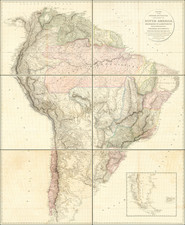
Rare second edition of Aaron Arrowsmith's gargantuan map of South America, corrected from the original edition of 1811, by far the most detailed and accurate map of the continent available during the period of the Spanish Latin American Wars of Independence (1810-21).
This monumental masterpiece is the finest and most detailed map of South America created during the Late Enlightenment era. It measures, once all six sheets are assembled, over 6.5 x 4.5 feet and is based on the very finest available sources, carefully edited by Arrowsmith. The coastlines are delineated based on the most recent sea charts, many done by trigonometric surveys regulated by astronomical observations. The interior river systems and mountain ranges, many only recently mapped for the first time, are expressed with great care. The political divisions, as they existed at the beginning of the ongoing Spanish Latin American Wars of Independence (1810-21), are carefully drawn and distinguished by their own original wash colors.
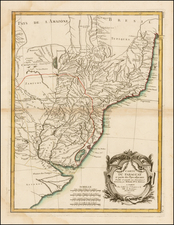
Of the Spanish political jurisdictions, the map marks the Captaincy General of Caracas (Venezuela), the Viceroyalty of Nueva Granada (modern Columbia and Ecuador), the Viceroyalty of Peru (modern Peru and Bolivia), the Captaincy General of Chile (modern Central Chile) and the Viceroyalty of La Plata (modern Northern Argentina, Uruguay and Paraguay). The numerous Portuguese Brazilian Captaincies include, Rio Grande, Sao Paulo, Minas Gerais, Mato Grosso, Para and Rio de Janeiro, amongst others. In the far northeast are the colonies of Dutch Guyana (soon to be divided into what is now Surinam and (British) Guyana) and French Guyana.
Arrowsmith described his sources as being based "Partly from Scarce and Original Documents, Published Before the Year 1806, but principally from Manuscript Maps & Surveys made between the years 1771 and 1806, corrected from accurate astronomical observations to 1810". While his sources are so varied that they are difficult to unravel, it is clear that Arrowsmith, who had privileged access to British official archives and cartography, had a rich variety of antecedents to choose from. Many very fine maps of Spanish South America had been printed during the 18th Century. Also, numerous important manuscript maps had found their way to London via the enlightened contacts between the Academia Real in Madrid and the Royal Society. Also, the British Royal Navy had seized many maps from Spanish ships during the ongoing Napoleonic Wars. Moreover, many Spanish officials and Latin American revolutionaries had fled into exile in London, bringing their maps with them. Outside of Spanish sources, the British were close allies with the Portuguese royal court (since 1808 resident in Rio de Janeiro) and were given special access to cartographic sources on Brazil.
In terms of the printed sources, we know that Arrowsmith improved upon Louis Stanislas d'Arcy Delarochette's Colombia Prima or South America (London, 1807), printed by Arrowsmith's archrival and former employer, William Faden. This map, in turn, improved upon Juan de la Cruz Cano y Olmedilla's Mapa Geografico de America Meridional (Madrid, 1775), the first broadly accurate large format map of South America. Arrowsmith's map certainly takes into account Pedro Vicente Maldonado y Flores's magnificent map of Ecuador, Carta de la Provincia de Quito-Ecuador y sus adyacentes (Paris, c.1750). For Peru, it embraces the surveys of Father Francisco Manuel Sobreviel, conducted in the 1780s. Arrowsmith's depiction of Northern Argentina, Uruguay and Paraguay is largely based on the updated 1760 version of Francisco de Avila's map, based on Jesuit sources, first printed in 1726.
Arrowsmith's depiction of Brazil is, in good part, predicated on a variety of highly authoritative Portuguese sources, including the maps brought to London in 1792 by Luis Pinto de Sousa Coutinho (1735-1804), the Viscount of Balsemão, who served as Portugal's Foreign Minister, from 1788 to 1801. Coutinho had previously been the Governor of the Captaincy of Mato Grosso from 1769 to 1772. Another key source were the maps done by the military engineer João Joaquim da Rocha, who was the first to map Minas Gerais in detail during the period between 1777 and 1798. The mapping of the São Paulo region is based on the work of João da Costa Ferreira (1750-1822), who served for many years as a military engineer in the region.
The mapping of Dutch Guyana (which was currently under British occupation), was largely based on the surveys done by Alexandre de Lavaux, published in 1737 but with notable recent improvements.
The first edition of the present map was issued in 1811, however the present second edition features notable improvements, especially relating to the coastlines between Buenos Aires and Rio and on the northeast coast of Brazil near Maranham.
This 1814 edition was issued separately and was also included in Arrowsmith's Atlas, made to accompany George Alexander Thompson's edited edition of Antonio de Alcedo's Dictionary of America and West Indies, called "Thompson's Alcedo" (London, 1815), a rare and highly important work on Latin Americas.
Historical Context
The present map appeared at an especially critical time in the history of South America. In 1814, much of the continent was embroiled in the Spanish Latin American Wars of Independence (1810-21), during which all of Spain's South American possessions won their independence. The South American leaders, or "Libertadors", Simón Bolívar (Venezuelan), José de San Martín (Argentinian) and Bernardo O'Higgins (Chilean), were all supported by Britain. After being essentially banned from trading with Spanish South America during colonial times, British leaders were excited about the prospect of investing heavily in South America under the new regimes and so this map would have been imbued with great value in the parlors of London.
Likewise, Britain was granted special trading privileges with Portuguese Brazil, in return for recently liberating its ancient ally, Metropolitan Portugal, from Napoleon's brutal French occupation. Up to this time, Brazil largely remained an enigma in minds of the powerful in London and this map would have done much to introduce this vast and magnificent land to key investors and diplomats.
An area of direct involvement for the British was Dutch Guyana, which since 1796 had been occupied by British forces. In 1816, Britain would acquire the western part of this territory, along the Essequibo and Demerara estuaries, which would become British Guyana. British Guyana was Britain's greatest single source of sugar during the 19th Century.
Aaron Arrowsmith: Leading Cartographer of his Time
Aaron Arrowsmith (1750-1823) was the easily most important cartographer in the world during the first quarter of the 19th Century. During this exciting period, which featured the Napoleonic Wars and mass political revolutions and great geographical discoveries in the Americas, Britain consolidated her dominance over global trade and military affairs. Arrowsmith's specialty was monumental maps of vast regions, such as the present work, based on cutting-edge sources. Indeed, Arrowsmith had an uncanny ability to acquire the best base maps before any of his competitors. His editing skills were also superlative, as he was always able to sort the geographical wheat from the chaff. In addition to the present map of South America, Arrowsmith's key masterpieces included: A Map Exhibiting all the New Discoveries, in the Interior Parts of North America (1795), A Map of the United States of North America (1796), A New Map of Mexico and Adjacent Provinces (1810) and his gargantuan map of India (1804). After his death, his business was continued by his nephew, John Arrowsmith (1790-1873).
Arrowsmith's monumental map of South America separately appears only very rarely on the market. It is an anchor map for any serious collection involving South America or any of its individual countries.
The Arrowsmiths were a cartographic dynasty which operated from the late-eighteenth century to the mid-nineteenth. The family business was founded by Aaron Arrowsmith (1750-1823), who was renowned for carefully prepared and meticulously updated maps, globes, and charts. He created many maps that covered multiple sheets and which were massive in total size. His spare yet exacting style was recognized around the world and mapmakers from other countries, especially the young country of the United States, sought his maps and charts as exemplars for their own work.
Aaron Arrowsmith was born in County Durham in 1750. He came to London for work around 1770, where he found employment as a surveyor for the city’s mapmakers. By 1790, he had set up his own shop which specialized in general charts. Arrowsmith had five premises in his career, most of which were located on or near Soho Square, a neighborhood the led him to rub shoulders with the likes of Joseph Banks, the naturalist, and Matthew Flinders, the hydrographer.
Through his business ties and employment at the Hydrographic Office, Arrowsmith made other important relationships with Alexander Dalrymple, the Hudson’s Bay Company, and others entities. In 1810 he became Hydrographer to the Prince of Wales and, in 1820, Hydrographer to the King.
Aaron Arrowsmith died in 1823, whereby the business and title of Hydrographer to the King passed to his sons, Aaron and Samuel, and, later, his nephew, John. Aaron Jr. (1802-1854) was a founder member of the Royal Geographical Society (RGS) and left the family business in 1832; instead, he enrolled at Oxford to study to become a minister. Samuel (1805-1839) joined Aaron as a partner in the business and they traded together until Aaron left for the ministry. Samuel died at age 34 in 1839; his brother presided over his funeral. The remaining stock and copper plates were bought at auction by John Arrowsmith, their cousin.
John (1790-1873) operated his own independent business after his uncle, Aaron Arrowsmith Sr., died. After 1839, John moved into the Soho premises of his uncle and cousins. John enjoyed considerable recognition in the geography and exploration community. Like Aaron Jr., John was a founder member of the RGS and would serve as its unofficial cartographer for 43 years. Several geographical features in Australia and Canada are named after him. He carried the title Hydrographer to Queen Victoria. He died in 1873 and the majority of his stock was eventually bought by Edward Stanford, who co-founded Stanford’s map shop, which is still open in Covent Garden, London today.
![America [Manuscript Map Showing the Sea of the West!]](https://storage.googleapis.com/raremaps/img/small/41297dm.jpg)
![[Signed Political Satire Artwork] Vietnam ... Vietnam ... Vietnam ...](https://storage.googleapis.com/raremaps/img/small/68726.jpg)