|
||

|

|
|

|
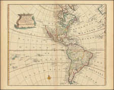
Fine example of the 1572 edition of Munster's map of America, the earliest map to show all of North and South America in a true continental form.
The first edition of the map appeared in Munster's Geographia, first published in 1540. However, it was the map's inclusion in the 1544 edition of Munster's Cosmographia that forever caused America to be the name of the New World, perpetuating Waldseemuller's choice of names in a popular and widely disseminated work.
Munster's map is the earliest map to show all of the continent of America and the first to name the Pacific Ocean (Mare Pacificum). The depiction of North America is dominated by one of the most dramatic geographic misconceptions to be found on early maps-the so-called Sea of Verrazzano. The Pacific cuts deeply into North America so that the part of the coastline at this point is a narrow isthmus between two oceans. This was the result of Verrazzano mistaking the waters to the west of the Outer Banks, the long barrier islands along North Carolina, as the Pacific. The division of the New World between Spain and Portugal is recognized on the map by the Castille and Leon flag planted in Puerto Rico, here called Sciana.
The map includes a host of firsts, including a very early appearance of the Straits of Magellan, along with Magellan's ship Victoria in the Pacific. Earliest appearance of Japan on a map, predating European contact and based solely on legends, such as Marco Polo's accounts of the region. The Yucatan Peninsula is shown as an Island. Lake Temistan (unnamed in this state of the map) empties into the Caribbean. The mis-information provided by Verazanno is perpetuated. The map depicts cannibals in South America and names Florida.
The present edition is from the 1572 German edition of Munster's Cosmographia and can be distinguished from earlier examples by the following 3 factors:
- Temistan is shown (it appeared on the map from 1540 to 1552 but was removed on the 1554 and later editions and later re-added in 1572).
- Sciana is not shown beneath the flag near Hispaniola (1558 editions only; added back in 1559).
- The phrase "Nova Insula Atlantica. . . " appears below Novus Orbis in South America (the phrase first appeared in 1558 as "ova Insula . . ." and was changed to "Nova Insula . . . " in 1561.
It should be noted that this example includes the word "maho" rather than the complete place name "Chamaho" in Mexico. This change appearently occurs in 1572, although it is not mentioned in Burden.
Sebastian Münster (1488-1552) was a cosmographer and professor of Hebrew who taught at Tübingen, Heidelberg, and Basel. He settled in the latter in 1529 and died there, of plague, in 1552. Münster made himself the center of a large network of scholars from whom he obtained geographic descriptions, maps, and directions.
As a young man, Münster joined the Franciscan order, in which he became a priest. He then studied geography at Tübingen, graduating in 1518. He moved to Basel, where he published a Hebrew grammar, one of the first books in Hebrew published in Germany. In 1521 Münster moved again, to Heidelberg, where he continued to publish Hebrew texts and the first German-produced books in Aramaic. After converting to Protestantism in 1529, he took over the chair of Hebrew at Basel, where he published his main Hebrew work, a two-volume Old Testament with a Latin translation.
Münster published his first known map, a map of Germany, in 1525. Three years later, he released a treatise on sundials. In 1540, he published Geographia universalis vetus et nova, an updated edition of Ptolemy’s Geographia. In addition to the Ptolemaic maps, Münster added 21 modern maps. One of Münster’s innovations was to include one map for each continent, a concept that would influence Ortelius and other early atlas makers. The Geographia was reprinted in 1542, 1545, and 1552.
He is best known for his Cosmographia universalis, first published in 1544 and released in at least 35 editions by 1628. It was the first German-language description of the world and contained 471 woodcuts and 26 maps over six volumes. Many of the maps were taken from the Geographia and modified over time. The Cosmographia was widely used in the sixteenth and seventeenth centuries. The text, woodcuts, and maps all influenced geographical thought for generations.