


|
||

|

|
|

|
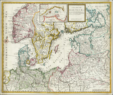
Fine old color example of Justus Danckert's map of Denmark and the southern parts of Sweden and Norway, based upon an earlier map by Frederick De Wit.
Centered on Copenhagen and Lund. Extends to Hamburg, Wismar, Rostock and Wolgast. Ornate cartouche with coat of arms.
The Danckerts were a family of Dutch engravers and geographers who produced geographic materials, including a series of original atlases. Initially, Justus I Danckerts (1635-1701) was a book and print publisher based in Amsterdam. His great-uncle, Cornelis Danckerts de Rij, (1561-1634) was a surveyor who produced a Kaert-boeck showing various views of Amsterdam. His brother, Dancker Danckerts (1634-1666), was a skilled engraver who produced several maps. Justus I was most likely influenced by both their work when he followed his father, Cornelis I Danckerts (1603-1656), into the publishing business.
In the early 1680s, Justus decided to embark upon a new project, an atlas with all the maps made in house. Such a project was feasible because two of his sons with his wife, Elisabeth Vorsterman, Theodorus I (ca. 1663-ca. 1720) and Cornelis II (1664-1717) had recently come of age and were trained in engraving and etching. Justus’ decision was most likely influenced by his surroundings; Amsterdam was the center of map publishing in the seventeenth century and in the 1680s several local publishers sought to join the atlas market then dominated by the Blaeu and the Hondius-Janssonius atlases.
Together, the brothers created their first maps in the mid-1680s. In 1684, the family received a 15-year privilege to protect their maps and they were then publishing both folios sized maps, the basis of an atlas, and wall maps for sale. Their first atlases contained around 20 original maps and 4-5 maps by other cartographers like Visscher and De Wit. The first known atlas to contain only Danckert maps was a 26-sheet volume published in 1690. As a guide, the Danckerts turned to similar atlases by De Wit, but by 1690 they clearly had the knowledge and capacity to produce their own original work.
After the first 26-sheet atlas, the Danckerts released a 37-sheet (1692-4), a 50-sheet (1694-6), and a 60-sheet (1698-1700) atlas. Several of the maps added to the atlases in the 1690s reflect the theater of the Great Alliance War (1688-1697). Other political events also influenced the contents of the atlases. For example, the English and Irish sheet maps were altered in 1688-9 and 1689-91 respectively, just after the Glorious Revolution of 1688.
In 1692, Justus II (?-1692), a third son of Justus I, died. A series of maps bearing a distinct style which abruptly stopped at this time have been attributed to him. A family member assumed to be another son of Justus I, Eduard (?-after 1721) came of age around the same time. Analysis of engraving style suggests that Eduard was heavily involved in the engraving process, working alongside Theodorus I and with another relation, also presumed to be a younger son of Justus I, Johannes (?-1712), thereafter.
Justus I drew up his will in 1696 and most likely retired from daily management of the shop at this time, although he lived until 1701. The aforementioned Johannes, who had a distinct engraving style, began contributing to the map engraving in 1700, although most of the maps he worked on are published under the name of another brother. The privilege had expired in 1699 and its renewal in the same year, before the death of Justus I, could explain why his sons continued to publish in his name after his death. Using the well-known name of Justus could protect the younger sons whose own reputation was not yet established.
In the new century, many of the maps were reworked or completely redone, as was the case with the world map and those of the continents. New maps were added to reflect the new areas of fighting in the War of the Spanish Succession, including new depictions of Italian states, the southern Netherlands, and the German provinces. In 1706, Albert Schut joined the business as an engraver and etcher and his name appears on maps from then onward. Between 1700 and 1712, the number of atlas maps increased to 75 and then 100 sheets. It seems Cornelis II was the main voice in atlas contents during this time, while Theodorus I’s role is unclear.
Johannes died in 1712, radically changing the business’ daily routine. Johannes had not only been an engraver, but also the firm’s representation to the Frankfurt Book Fair, the largest book fair in Europe at that time. As the German market was the main source of income for the Danckerts, his death was a heavy blow.
Over the next two decades, the pace of new map production slowed drastically. Only two known maps made during this period are known today: a third world map, engraved by Jacob Folkema, and a Hispania map published with Cornelis II’s name. Neither of these featured in the atlases. After 1717, when his father Cornelis II died, a few maps were reworked by Theodorus II and the contents of the atlases were altered slightly to include those printed from unfinished plates.
By 1726, Theodorus II was in debt. He gave much of his stock to a creditor, T. Rijswick, just before he died in 1727. The stock was sold at auction by Rijswick and other publishers, including the Ottens and Van Keulen, bought plates from the atlas.
Lack of biographical data is a problem for all the Danckerts, especially the younger brothers. Justus I was born in Amsterdam, where he also began his business. All the sons were born and presumably died there. Justus II’s death date is all that has survived of him in the records, and all that is known of Eduard is that in 1721 he served as uncle and guardian to Theodorus II (ca. 1701-1727), the son of Cornelis II. After that nothing is known of him. Theodorus I most likely died between 1718 and 1721. He had a son, Gerit (ca. 1708-after 1731), but the lad does seem to have become a map engraver. With the death of Theodorus II, therefore, there were no more Danckerts to carry on the business even if Theodorus II had avoided debt.
Although not as long-lived as some of the other family firms, for the decades surrounding the turn of the seventeenth-century the Danckert family produced well-respected and widely distributed wall maps and atlases. They joined the atlas trade at a time when atlases were increasing in popularity and the expansion in the number of sheets included in their atlases indicate both their popularity and the skill of the engraving brothers.
![[ Halmstads Chiefdom, Southwestern Sweden ] Karta öfver Halmstads Höfdingedöme eller Halland Utfivven Af Frieherre S.G. Hermelin Författad . . . . af Carl G. Forssell. 1807](https://storage.googleapis.com/raremaps/img/small/99085.jpg)
![[ Baltic Sea / Sweden / Poland / Rugen ] De Custen van Denemarcken en Sweden, van Valsterbon tot Schenkenes, als mede de cust vanten van Pomeren van't eylant Rugen tot Rygshooft . . .](https://storage.googleapis.com/raremaps/img/small/99944.jpg)
![[Finland] Postkarte von Finnland und Norrland / Tabula qua Curus Veredarii Per Pinnoniame et Norrlandiam](https://storage.googleapis.com/raremaps/img/small/57036.jpg)
![[Denmark and Southern Sweden] Danorum Marca, vel Cimbricum, aut Daniae Regnum . . . M. D. LXXXV.](https://storage.googleapis.com/raremaps/img/small/91201.jpg)