|
||

|

|
|

|
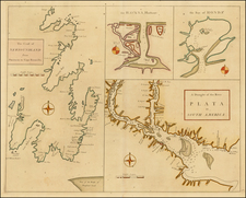
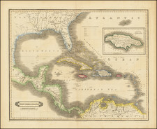
Fine example of the Laurie & Whittle edition of Jefferys' chart of the Coastline from Cartagena, Colombia to Nicaragua, centered on Costa Rica, and Panama, from Jefferys' West India Atlas.
This is one of the most detailed English language maps of the region published in the second half of the 18th Century and illustrates the region shortly before the end of the Spanish Colonia era. One of the primary functions of the map is to illustrate the route of the Spanish Galleons between Cartagena and Porto Bello. Sailing ships on the map also illustrate significant ports in the region.
The chart shows a significant number of English place names, reflecting the extensive English history of the so-called Moskito Coast.
In the early 17th Century, a region which became know to the English called the "Mosquito Kingdom" was present on the coastline. One of the kings of this region visited England around 1638 at the behest of the Providence Island Company and sealed an alliance with Great Britain.
The first British contacts with the Mosquito region started around 1630, when the agents of the English chartered Providence Island Company - of which the Earl of Warwick was chairman and John Pym treasurer - occupied two small cays and established friendly relations with the local inhabitants. Providence Island, the company's main base and settlement, entered into regular correspondence with the coast during the decade of company occupation, 1631-41.
The Providence Island Company sponsored the Miskito's "King's Son" to visit England, during the reign of Charles I (1625-49). When his father died, this son returned home and placed his country under English protection. Following the capture of Providence Island by Spain in 1641, England did not possess a base close to the coast. However, shortly after the English captured Jamaica in 1655, they recommenced relations with the coast and Oldman went to visit England.
The Miskito King Edward I and the British concluded a formal Treaty of Friendship and Alliance in 1740 and Robert Hodgson, Senior, was appointed as Superintendent of the Shore. The language of the treaty includes what amounts to a surrender of sovereignty and is often taken by historians as an indication that a British protectorate was established over the Miskito Kingdom.
Britain's primary motive and the most immediate result of the treaty was to secure an alliance between the Miskito and British for the War of Jenkin's Ear and the Miskito and British cooperated in attacks on Spanish settlements during the war. This military cooperation would prove important as Miskito forces were vital to protecting not only British interests in the Miskito Kingdom but also for British holdings in British Honduras (now Belize).
A more lasting result of this formal relation was that Edward I and other Miskito rulers who followed him allowed the British to establish settlements and plantations within his realm and issued the first land grants to this effect, in 1742. British settlement concentrated especially in the Black River area, Cape Gracias a Dios and Bluefields (named for a region of the same name in Jamaica). The British plantation owners used their estates to grow some export crops and as bases for the exploitation of timber resources, especially mahogany. Most of the labor on the estates was supplied by African slaves and by indigenous slaves captured in Miskito and British raids into Spanish territory. By 1786, there were several hundred British residents on the shore and several thousands slaves, mostly African.
The Miskito kings received regular gifts from the British in the form of weapons and consumer goods and provided security against slave revolts and capturing runaways.
Spain, which claimed the territory, suffered considerably from the Miskito attacks which continued during peacetime. When the American Revolutionary War broke out, Spanish forces attempted to eliminate the British presence, seizing the settlement at Black River and driving British settlers from the isle of Roatán; however, this ultimately failed when armed settlers led by the Anglo-Irish soldier Edward Despard, retook the settlements.
Although Spain had been unable to drive the British from the coast or occupy any position, in the course of the diplomatic negotiations following the war, Britain found itself making concessions to the Spanish. In the 1786 Convention of London, Britain agreed to evacuate British settlers and their slaves from the Mosquito Coast to their, as yet, informal colony in what was to become British Honduras (now Belize); later treaties recognized Britain's commercial but never territorial, rights in the region. Some of the settlers and their slaves remained after they swore loyalty to the King of Spain, especially in Bluefields.
The Mosquito Coast was initially annexed (or from the Spanish point of view, re-annexed) to the Captaincy General of Guatemala. Since the beginning however, poor land communication with Guatemala City made it easier for the Miskito elites to sail to Cartagena de Indias and swear fealty to Spain, before the Viceroy of New Granada, instead.
Viceroy Francisco Gil de Taboada even suggested that government over the Mosquito Coast should be transferred to Havana, Cuba, mirroring the long-standing relation that the Mosquito Kingdom had earlier with British Jamaica but this idea was rejected by the Spanish Crown. Guatemala protested the perceived unruliness of the Spanish appointed governor at Bluefields, a former British Superintendent of the Mosquito Coast who had sworn recent fealty to Spain, Robert Hodgson Jr. His loyalty and good work were defended by the New Granadan Viceroy José Manuel de Ezpeleta, who succeeded Taboada in 1789 and considered that Hodgson's influence among the Miskito was vital to avoid a revolt. Hodgson Jr. was the son of Robert Hodgson Sr., the first British appointed Superintendent in 1749-1759. He had occupied this post from 1767 to 1775, when his political enemies persuaded Lord George Germain to replace him with James Lawrie, the last British Superintendent before the evacuation and a declared adversary of Hodgson.
The Spanish hoped to win over support of the Miskito elite by offering presents like the British had and educating their youth in Guatemala, as many Miskito had been educated previously in Jamaica. Catholic missionaries also travelled to the coast with the aim of converting the native population in this period. The acceptance of the new order was unequal and often influenced by the underlying tensions within their own Miskito elites. They were divided between the northern regions controlled by the Sambu, loyal to King George II Frederic, who remained himself friendly to the British and the Tawira southerners alligned with Admiral Briton, who developed closer ties with Spain and adopted the name Don Carlos Antonio Castilla, after his own conversion.
The Spanish also sought to occupy the positions formerly held by British settlers with their own colonists. Beginning in 1787, around 1,200 settlers were brought from the Iberian Peninsula and the Canary Islands. They settled in Sandy Bay, Cape Gracias a Dios and Black River but not in the new capital Bluefields.
The new colony suffered setbacks as a result of many of the settlers dying en route and the Miskito Crown showing its dissatisfaction with the gifts offered by the Spanish. The Miskito resumed trade with Jamaica and when news of another Anglo-Spanish War arrived in 1797, George II raised an army to attack Bluefields, deposing Hodgson and drove the Spanish out of the kingdom on September 4, 1800. However, the king died suddenly in 1801. According to British George Henderson, who visited the Mosquito Coast in 1804, many in the kingdom believed that George II had been poisoned by his brother Stephen as part of a deal with the Spanish. In order to prevent Stephen from seizing power for himself, the General Robinson spirited George II's young heir George Frederic Augustus I to Jamaica by way of Belize and established a regency in his name.
With Spanish power over the Mosquito Coast vanished and British influence rapidly returning, the Captaincy General of Guatemala sought full control of the shore to Spain. The Colombian Ricardo S. Pereira, writing in 1883, considered this act a miscalculation on the part of the Real Audiencia of Guatemala: had they simply raised an army and marched on the Mosquito Coast, nobody would have questioned that the area was part of the Captaincy General once Spanish power was fully restored. Instead, the Spanish government heeded the old advice exposed by Gil de Taboada and Ezpeleta, and decided against Guatemala's request on November 30, 1803, reaffirming the control of the Viceroyalty of New Granada over the Archipelago of San Andrés, Providencia and Santa Catalina (used by New Granadan coast guards as a base against British privateers, often coming from the Mosquito Coast itself) and transferring sovereignty over the Mosquito Coast to New Granada for considering the area dependent of San Andrés. While Spanish rule was never restored over the Mosquito Coast (instead, the British occupied the Archipelago itself in 1806, during the course of the war against Spain), the Royal Decree of 1803 became the reason for territorial disputes between the United Provinces of Central America and Gran Colombia, after Latin American independence and between Nicaragua and Colombia, for the rest of the 19th century.
Richard Holmes Laurie (1777-1858) was the son of mezzotint engraver Robert Laurie, who had taken over Robert Sayer's publishing house with James Whittle in 1794. Richard Holmes Laurie joined in a partnership with Whittle when his father retired in 1812. The name of the firm then switched from Laurie & Whittle to Whittle & Laurie. Whittle died in 1818, leaving Richard Holmes to continue publishing alone as R. H. Laurie.
When the Hydrographic Office opened in 1795, it was tasked with creating and producing all the nautical charts for the Royal Navy so as to wean the Navy off dependence on foreign charts. By the 1820s, private publishers were augmenting HO charts and competing with them, including Richard Holmes Laurie. Richard gave up publishing anything except nautical materials by 1830. He also sold charts to Trinity House, the lighthouse and maritime safety fraternity. He died in 1858.
The firm continued to print under the name R.H. Laurie even after 1858. Later, the firm was managed by Laurie’s draughtsman, Alexander George Findlay, and, later, Daniel and William Kettle.
James Whittle (1757-1818) was a British engraver and map printer. Whittle was employed by Robert Sayer (ca. 1725-1794). Together with Robert Laurie (1755?-1836), he took on Sayer’s business when the older man died in 1794. The two traded together as Laurie & Whittle until 1812, when Laurie retired. They had specialized in sea charts and maritime atlases. Whittle then partnered with Laurie’s son, Richard Holmes Laurie, until he died in 1818.