
![(Carolinas) Virginiae Partis australis, et Floridae partis orientalis, interjacentiumqus regionum Nova Descriptio [A New Description of the Southern Part of Virginia and the Eastern Part of Florida, and the Intervening Regions.] By Jan Jansson](https://storage.googleapis.com/raremaps/img/small/94131.jpg)


|
||

|

|
|

|
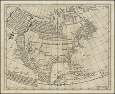
Nice example of Jansson's map of the Southeast.
Jansson's map of the Carolinas and Blaeu's map of the Carolinas are virtually indistinguishable cartographically, although there are a number of minor differences in the embellishments. Both maps are on the larger 1606 Mercator-Hondius map of the Carolinas but with significant improvements. The map covers an area from the mouth of the Chesapeake Bay to Georgia and reflects the competing interests of France and England in the New World, with the coat of arms of each country identifying the regional control. As noted by Burden, the French claims are supported primarily by the French colonization efforts of the 1560s.
As noted by Burden,
The greatest improvement occurs in the northern half of the map north of Porto Royal. Whereas on the Hondius [map] the coastline towards C. de. Ste. Romano (present day Cape Fear) veered directly east, Blaeu more correctly takes it north-east, placing the cape closer to its true position of 34 degrees. This span of coastline is approximately that of present day South Carolina. This now presents to us a more accurately proportioned Outer Banks region, radically reduced in size but still slightly too far north. For these improvements, Blaeu drew upon the extremely rare DE EYLANDEN . . . by Hessel Gerritsz., c. 1631. The Outer Banks combine the placenames of Gerritsz and Hondius, often using two different ones for the same area . . .
Chesapeake Bay was depicted just as a small bay on Hondius' map of 1606, as John Smith was yet to explore these waters. The Gerritsz terminated at this point, and only two placenames appeared. Blaeu draws largely on Smith's map for much of the nomenclature, but introduces some English [names] from an unknown source. The most important is Newport News. Newport News, founded in 1621 and apparently shown here for the first time on a printed map. Also new are Bermouth, Stortingen and Arglas . . .
Includes the marvelous mythical lakes in the interior and other conjectural cartography of the time. Large cartouche, 2 coats of arms, 2 compass roses and several sailing ships. Blaeu's map is nearly identical to Jansson's map. The easiest way to distinguish the two maps is by the erroneous longitudinal number 200 in the lower right corner on Blaeu's map. The correct number (300) appears on Jansson's map.
Jan Janssonius (also known as Johann or Jan Jansson or Janszoon) (1588-1664) was a renowned geographer and publisher of the seventeenth century, when the Dutch dominated map publishing in Europe. Born in Arnhem, Jan was first exposed to the trade via his father, who was also a bookseller and publisher. In 1612, Jan married the daughter of Jodocus Hondius, who was also a prominent mapmaker and seller. Jonssonius’ first maps date from 1616.
In the 1630s, Janssonius worked with his brother-in-law, Henricus Hondius. Their most successful venture was to reissue the Mercator-Hondius atlas. Jodocus Hondius had acquired the plates to the Mercator atlas, first published in 1595, and added 36 additional maps. After Hondius died in 1612, Henricus took over publication; Janssonius joined the venture in 1633. Eventually, the atlas was renamed the Atlas Novus and then the Atlas Major, by which time it had expanded to eleven volumes. Janssonius is also well known for his volume of English county maps, published in 1646.
Janssonius died in Amsterdam in 1664. His son-in-law, Johannes van Waesbergen, took over his business. Eventually, many of Janssonius’ plates were sold to Gerard Valck and Pieter Schenk, who added their names and continued to reissue the maps.
![[Amherst County Survey of 200 Acres Owned by Captain James Dillard dated 16, 1822]](https://storage.googleapis.com/raremaps/img/small/73745.jpg)

![[ Carolinas & Georgia ] Virginiae Partis australis, et Floridae partis orientalis, interjacentiumqus regionum Nova Descriptio](https://storage.googleapis.com/raremaps/img/small/81554.jpg)
![[ Georgia Coast ] Sex alia flumina a Gallis observata. IIII.](https://storage.googleapis.com/raremaps/img/small/97965.jpg)
