|
||

|

|
|

|
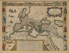
A Fine example of the first edition Willem Blaeu's exceedingly rare, separately issued and large-format sea chart of Europe.
This large and sumptuously decorative chart is one of the rarest and most historically important monuments of Dutch Baroque cartography, and a milestone in the career of the celebrated mapmaker Willem Jansz Blaeu. It is also exceedingly rare in the first edition, with no examples recorded in British or American institutional collections.
Blaeu's chart captures the entire coastlines of Europe and the shores of the Mediterranean Sea. The coverage of the main part of the chart commences in the northeast at Novaya Zemlya, then follows the intricate European coastline past Norway, into the Baltic Sea, then down through the North Sea and the Atlantic littoral, through the Pillars of Hercules to take all of the Mediterranean Sea west of Corfu, along with the adjacent coastlines of North Africa. It also extends deep into the North Atlantic to feature Iceland, Greenland, Spitsbergen and the Azores. The latter is important as the location of the Prime Meridian of Longitude (before it was changed later in the century to 'Pico' in Tenerife, and then to Greenwich in the 19th Century), and an important marker for ships sailing to the West Indies and South America. A beautiful inset in the lower left of the chart details the shorelines of the Eastern Mediterranean.
The chart is oriented with the west towards the top and assumes a Portolan-style appearance, with sparing geographic detail in the interior, but neat and tightly clustered place names along the littoral, while the seas are traversed by rhumblines, emanating from compass roses. The interior areas are adorned with the elaborate national coats of arms of various nations, including those of Russia, Sweden, Denmark-Norway, the Holy Roman Empire, England, France, Spain and the Ottoman Empire. Four scale cartouches adorn the corners, while a magnificent title cartouche, topped by Blaeu's symbol of an armillary sphere and with his motto "Indefessus Agendo" ('Act Steadily') graces the lower-center of the chart. The seas are further embellished with sailing ships and seals, while on the land roam Inuit hunters, goats, bears and elephants.
Importantly, the chart is one of the earliest maps to include details of the waters around Greenland and the Davis Strait, on the west coast of the island, after the 1612 map of Hessel Gerritsz, a cartographer closely associated with Blaeu. Blaeu also makes a step forward in omitting the mythical island of 'Friesland', which was still included on many contemporary charts.
While most of the coastlines of Europe are well charted and fully familiar to the modern eye, the Russian Arctic coastline, in the lower right of the chart, remains partially undefined. The chart presents the most advanced knowledge of the region, largely based on the recent charting done by Dutch explorers. In particular, Blaeu shows the western coasts of Novaya Zemlya, discovered by Willem Barentsz in the 1590s, although he is cautiously silent on whether or not the landform is an island.
Blaeu based much of the cartography of the present chart on a chart he made in 1606, although the Pascaarte van alle de Zecusten van Europa is much larger and more detailed.
Historical Context
Blaeu devised the chart to take advantage of major events that were occurring with respect to the Dutch Republic's growing global ambitions. In 1621, the year that this chart was produced, the Dutch West India Company (the WIC) was formed in an effort to acquire commercial colonies in the Americas. The Company's mariners vitally needed such an omnibus chart that would guide their ships in approaching and clearing European inland waters, while being able to sail down between the Canaries and Azores to take advantage of the trade winds, and so to sail down towards the West Indies. In a short matter of time, the WIC founded New Amsterdam (1624, modern New York), conquered much of Northern Brazil (starting in 1630), and acquired Caribbean Islands such as Curaçao and part of Saint Martin (1630). To further assist the WIC, Blaeu published his West Indische Paskaert later the same year.
Another major interest was the Noordsche Compagnie (the Northern Company), established in 1614, which held a monopoly on all Dutch trade in the Arctic, which was primarily centered on whaling and fishing. The chart's progressive delineation of Arctic Russia and Scandinavia, Spitsbergen, Iceland and Greenland would have been most useful.
As the finest general sea chart of Europe made during its era, Blaeu's chart also had important military strategic value. In 1621, the Twelve Years' Truce in the Eighty Years' War (1568-1648) expired and the Dutch Republic and Spain renewed their epic conflict. Leading officials of the government of the Dutch Stadhouder, Prince Maurits of Orange-Nassau, as well as senior naval commanders, would certainly have consulted copies of the chart when planning their missions. Indeed, over the coming years the Dutch Navy came into combat with the Armada Real in wide variety of places, from the Mediterranean to the North Sea, so an accurate panoptic view of the continent would have been most beneficial.
Blaeu's magnificent chart thus acted as a 'calling card' for the WIC, the Noordische Company and the Dutch Navy, which ensured Blaeu a tremendous amount of business for the rest of his days.
Blaeu's chart proved to be highly influential and was copied many times over the next three generations, including editions by Anthonie Jacobsz, Pieter Goos, Justus Danckerts, as well as by Blaeu's own grandchildren Willem II, Pieter and Joan. Frederick De Wit also made a version of the chart, which cut off the region that included Greenland, which was copied by Renard and Ottens.
Perhaps most notably and fittingly, Blaeu's Pascaarte van alle de Zecusten van Europa was used by the great painter Vermeer as the backdrop to his painting 'The Geographer' (1669), which today resides in the Städel Museum in Frankfurt.
Willem Blaeu: The Leading Cartographer of his Era
Willem Jansz Blaeu (1571-1638) was the most important mapmaker of the 17th Century, and was responsible, more than any other figure, for the ascension of Dutch cartography to a globally dominant position. Blaeu, originally from Alkmaar, north of Amsterdam, apprenticed from 1594 to 1596 under the legendary Danish astronomer Tycho Brahe at his observatory on Ven Island, near Copenhagen.
Upon his return to the Netherlands, Blaeu started a business making charts, globes and nautical instruments. His timing was impeccable, as the Dutch economy, based on maritime trade, was booming and there was an insatiable demand for high quality sea charts and nautical kits. Notably, in 1596, the Dutch made their first voyage to the East Indies, which soon led to the establishment of the Dutch East India Company (1602). The VOC would be one of Blaeu's anchor clients and, in 1633, he would be appointed to be the Company's official hydrographer.
Blaeu's sea atlas of European waters, Het Licht der Zee-vaert (1608) was revolutionary, being the first broadly accurate maritime atlas. He went on to create magnificent wall maps, large-format charts and eventually terrestrial atlases, all decorated with the finest Dutch Baroque artistry. In particular, the Pascaarte van alle de Zecusten van Europa helped to establish Blaeu's supremacy in the highly competitive Dutch cartography market. Towards the end of his life, Blaeu published the Atlas Novus (1635), a grand production that was later expanded by his son, Joan Blaeu (1598-1673), who grew the Blaeu business into the largest geographic publishing house in history.
Rarity
The Pascaarte van alle de Zecusten van Europa was during its time a practical working sea chart. The map tended to be heavily used aboard ship, accounting for its low survival rate. It was printed on both paper (as with the present example) and on vellum. Both types are exceedingly rare, with only 8 institutional examples known (6 on vellum and only 2 printed on paper).
Gunther Schilder notes that of these examples none resides in American or British collections. The institutions which record examples are: Universiteitsbibliotheek Amsterdam; Stadsarchief Antwerpen; Staatsbibliothek zu Berlin; Nationalbibliothek Budapest; Hessesche Landesbibliothek, Darmstadt; Badische Landesbibliothek, Karlsruhe; Bibliotheque Nationale de France; Herzogin Anna Amalia-Bibliothek, Weimar; and the Stopp Collection.
Willem Janszoon Blaeu (1571-1638) was a prominent Dutch geographer and publisher. Born the son of a herring merchant, Blaeu chose not fish but mathematics and astronomy for his focus. He studied with the famous Danish astronomer Tycho Brahe, with whom he honed his instrument and globe making skills. Blaeu set up shop in Amsterdam, where he sold instruments and globes, published maps, and edited the works of intellectuals like Descartes and Hugo Grotius. In 1635, he released his atlas, Theatrum Orbis Terrarum, sive, Atlas novus.
Willem died in 1638. He had two sons, Cornelis (1610-1648) and Joan (1596-1673). Joan trained as a lawyer, but joined his father’s business rather than practice. After his father’s death, the brothers took over their father’s shop and Joan took on his work as hydrographer to the Dutch East India Company. Later in life, Joan would modify and greatly expand his father’s Atlas novus, eventually releasing his masterpiece, the Atlas maior, between 1662 and 1672.
![[ Eastern Hemisphere Globe Gores. ] (Nova et integra universi Orbis descriptio)](https://storage.googleapis.com/raremaps/img/small/54480.jpg)
![[Europe] Parte Occidentale Dell' Europa . . . [and] Parte Orientale Dell' Europa . . . [Coronelli's 2 sheet map of Europe]](https://storage.googleapis.com/raremaps/img/small/94402.jpg)