
This item has been sold, but you can enter your email address to be notified if another example becomes available.


|
||

|

|
|

|
Stock# 38596
Description
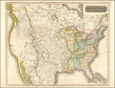
Interesting map of the United States, showing nice early western territorial borders.
No Arizona, or Colorado located. Very early depiction of Nevada Territory, which is shown with its narrowest configuration, before twice extending its border eastward, reducing the size of Utah and thereby shrinking the influence of the Mormons.
Washington & Oregon run to the Rockies and Nebraska extends to Canada. Locates a number of early forts. Massive Kansas extends to Utah.
![[ Early United States ] Etats Unis De L'Amerique](https://storage.googleapis.com/raremaps/img/small/98746.jpg)