|
||

|

|
|

|
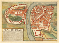
A rare and highly decorative separately-issued late 17th century map of Bohemia, based on the surveys of Johann Georg Mauritius Vogt, published in Nuremberg by Johnann Zieger.
This attractive and finely engraved map provides an exceedingly detailed view of Bohemia (the western part of the Czech Republic), as it appeared towards the end of the 17th Century. Every city, town and village is labeled, provincial boundaries are demarcated and all major forests and rivers are depicted.
Running along double-registers on both sides of the map are 60 portraits of the various historical rulers of Bohemia, many of whom were also Kings of Poland. The upper corners of the map are adorned with the Bohemian lion rampant and the Habsburg double-headed eagle carrying and brandishing a sword and an orb.
Johann Georg Mauritius Vogt (Czech: Jan Jirí Moric Vogt, 1669-1730) was a Cistercian monk and land surveyor based at the Abbey of Plasy, near Plzen. Originally from Bavaria, Vogt was sent to Bohemia by the ruling Habsburgs as part of a broader effort to strengthen Roman Catholicism in the kingdom. Shortly after his arrival in Bohemia, Vogt became fascinated by the history and geography of the region. He conducted many surveys that he fashioned into the present map. The map was more planimetrically accurate than its predecessors and was only superseded by Johann Christoph Müller's gargantuan map of Bohemia of 1720.
The map was engraved by Johann Alexander Boener and published by Johann Zieger of Nuremberg. Zieger subsequently issued (circa 1712), a dramatically different version of Vogt's map, which was adorned by allegories of Bohemia's rivers instead of the royal portraits. The map is stylistically influenced by Jacob Sandrart's Bohemia in suas partes geograph: distinc:, published in 1666, which is dedicated to Emperor Leopold I (1640-1705) but shows singificant cartographic advances in accuracy. Sandrart in turn drew upon Jan Jansson's rare map of Bohemia, first published in 1620. /gallery/detail/37762
Importantly, the map had an, albeit subtle but significant political propagandist purpose. Vogt was a Roman Catholic priest loyal to the ruling Habsburg regime of Bohemia. While the kingdom was then securely under the rule of Emperor Leopold I (reigned 1658-1705), the dramatic events that had occurred in Bohemia in the earlier part of the century still colored perceptions.
In 1618, the largely Protestant Bohemian nobility overthrew the long-standing rule of the Catholic Habsburgs. In what was known as the 'Defenestration of Prague' a party of noblemen threw a trio of Habsburg emissaries out of a window. In August 1619, they elected Frederick V, the Elector Palatine, to be the King of Bohemia. However, Ferdinand II, the Habsburg Emperor, entered Bohemia with his armies and utterly crushed the forces of Frederick and the nobles at the Battle of White Mountain on November 8, 1620. The nobles were summarily executed and Protestantism was ruthlessly suppressed under Ferdinand's rule. More importantly, the crisis in Bohemia sparked the Thirty Years' War (1618-48), which killed over 8 million people, making it by far the most deadly conflict in European history, in proportional terms. As the century wore on, the Habsburgs were adamant that Bohemia would never again slip from their grasp.
The 60 portraits of rulers are rhetorically intended to legitimize the Habsburg regime by showing a continuous succession of divinely mandated rulers of Bohemia, from the ancient Slavic kings all the way up to Leopold I (unsurprisingly Frederick V's portrait has not been included!). This propagandist device was well-established in Bohemia and was likely inspired by the 'Gallery of the Kings' in St. Vitus Cathedral in Prague.
This map is very rare. We note only a restored example offered in 2005 by Reiss & Sohn at auction in the past 30 years (April 2005, #4085)
Given its historical importance, it is an essential piece for any serious collection of the cartography of the Czech Republic.
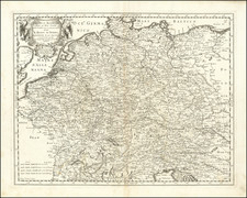
![Turingiae Noviss Descript. Per Iohannem Mellinger Halens [with] Misniae et Lustaiae Tabula Descripta a. M Bartholomeao Sculteto Gorlit.](https://storage.googleapis.com/raremaps/img/small/61448.jpg)
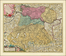
![[ Tyrolean Alps ] Status Tirolensis qui Complectiture Ipsissimum ejuldem Nominis et Anexum ei Brigantinae Comitatus. . .](https://storage.googleapis.com/raremaps/img/small/77215.jpg)