|
||

|

|
|

|
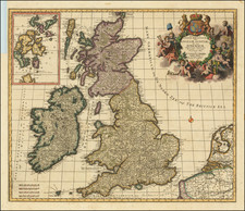
Fine early map of the British Isles, from Porcacchi's L'Isole Piu Famose Del Mondo…
Finely engraved with sea monsters, compass rose and decorative cartouche.
The map is based upon George Lily's 1546 map of the British Isles, perhaps the single most important map of the British Isles of the 16th Century.
Almost certainly intended as a companion-piece to the Descriptio Britanniae, Lily drew the first map of the British Isles (at a reasonably detailed scale) to be printed. It was engraved on two plates and published in Rome in 1546. The map is drawn in part from the 14th-century Gough Map, although the orientation has been reversed (west is at the top of the sheet) and many minor improvements have been made. The Scottish coastline, in particular, is considerably more accurate than that on the Gough Map but Lily's sources for this are not known.
![[English Channel] De Cust van Vlaenderen en Engelandt van Oostende tot deur de Hoofden](https://storage.googleapis.com/raremaps/img/small/75243.jpg)