|
||

|

|
|

|
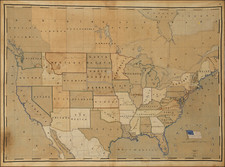
Fascinating map of the United States, illustrating the history of the American Indian, from 1840 to about 1900.
While styled as an Indian map and displaying the territorial borders of the United States prior to the formation of Nebraska Territory in 1854, the present map is more of a history of Indians, famous Americans and the west. The map is ringed with portraits of famous Indians and important figures from the American West. The historical vignettes range from the location and dates of the discovery of gold in several parts of the west, to the location of John Brown's hanging in 1859, to Lincoln's inaugural speech in 1861 and to Robert Fulton's construction of the first steamship.
The majority of the historical vignettes provide dozens of interesting western history facts and the location of important overland routes.
Danny Arnold is likely Daniel Alvin Arnold, one of the directors of the Old Western Trading Company of London.