|
||

|

|
|

|
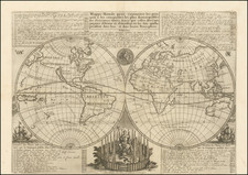
Rare separately issued map of the world, being the first printed map to depict Western Australia, first issued by Jodocus Hondius in about 1625 and engraved by Francis van der Hoeye.
This exceptional map is the earliest printed map to show the recent Dutch discoveries on the West Coast of Australia.
While Willem Jansz had become the first European known to have discovered Australia in 1606, landing on the coasts of the Gulf of Carpentaria in northern Queensland, the discovery of Western Australia was still another decade in the making.
In 1616, Dirk Hartog, captaining the Dutch East India Company (VOC) ship Eendracht (meaning 'Unity'), en route from the Netherlands to Indonesia accidentally went off course and encountered the west coast of the Australian mainland. He landed close to 26º South, at what is now known as Dirk Hartog Island in the Shark's Bay area of Western Australia.
Interestingly, Hartog left a pewter plate near the shore on the northern point of Dirk Hartog Island, on which he inscribed:
"1616 On 25 October arrived the ship Eendracht, of Amsterdam: Supercargo Gilles Miebais of Liege, skipper Dirch Hatichs of Amsterdam. on 27 d[itt]o. she set sail again for Bantam. Deputy supercargo Jan Stins, upper steersman Pieter Doores of Bil. In the year 1616."
Hartog's plate was found in 1696 by another Dutch explorer Willem de Vlamingh and replaced by another plate. De Vlamingh brought Hartog's plate to Amsterdam, where today it is on display at the Rijksmuseum.
After departing Dirk Hartog Island, the Eendracht sailed northwards along the western Australian coastline, all the while charting the Australian coastline. In honor of his voyage, he named the land "T Landt van d'Eendracht" (the Land of the Eendracht). By 1619 this name was applied in document to refer to all of Australia, a name used for the subcontinent until 1644, when it was replaced by "Nieuw Holland".
Hartog's cartography remained in manuscript form for some years, in part, because of the VOC's cartographic secrecy laws.
As noted by Rodney Shirley:
Five places are marked, corresponding to Dutch discoveries up to 1616-1619 takend from Hessel Gerritsz' manuscript map of the Indian Ocean of 1622. The discoveries of Carstensz along the Gulf of Carpentaria made in 1623 are not marked. Hondius had completely erased the large southern continent shown on his previous world map of 1617 and although there are general similarities the two hemispheres are not taken directly from the earlier map: North America, for instance, is much reduced in width and only occupies 140 degrees of longitude as its broadest point.
The map's geographical depictions in other parts of the World are also notable. The depiction of the east coast of North America bears no clear relation to any other printed map. The detailed rendering of North America's Pacific Northwest, complete with numerous fictitious place names, is also curious. South America is shown to have an usually exaggerated bulbous form.
Interestingly, the map shows an unusual land formation at the end the Indian Peninsula, which is likely due to an exaggerated reading of Jan Huyghen van Linschoten's 1596 chart of the western Indian Ocean. The depiction of East Asia is very rudimentary, as while China takes on a fairly fine form (after the early Jesuit sources), Korea is shown to be a misshapen island and southern Japan takes on a fairly crude appearance.
The map is embellished with allegorical figures depicting the seasons in the corners and the four elements in the center. In the upper center is a lengthy note to the reader.
A fascinating and enigmatic feature of the map is its inclusion of curved lines radiating from the compass roses, one located in the Pacific Ocean and the other in the Indian Ocean. While these lines may very well be an attempt to express the curvature of the earth, some have hypothesized that they are actually attempts to convey isolines, or the lines of magnetic declination. If so, they would predate Edmund Halley's A New and Correct Chart shewing the Variations of the Compass… (London, 1701) by over 75 years, thought to be the first printed map to employ isolines. While similar lines were employed on wall maps of the world issued by Willem Blaeu, Pieter van der Keere and others during this time period, we are aware of no other single sheet world map from the era that includes these lines. These curious lines are worthy of further academic investigation.
.
The map appeared in several states, as follows:
- Jodocus Hondius (undated, with Hondius' name in the top center).
- Franciscus Hoeius (dated 1630), who signs the plate below the celestial globe at the bottom center of the map.
- Clement de Jonghe (dated 1664).
- Johannes Van Keulen (1680s--3 different states).
The first two states of the map (Hondius and Hoeius) are exceptionally rare, this being the first example we are aware of as having appeared on the market.
The Hondius world map was soon followed by Hessel Gerritsz's Caert van't Landt van d'Eendracht (Amsterdam, 1627), a chart that specifically focused on the coasts of Western Australia, which also included the 1622 discoveries of the VOC galleon Leeuwin.
Francis van der Hoeye (aka Franciscus Hoeius, 1590-1636) worked in Amsterdam as a copper plate engraver and publisher from 1629 until his death in 1636 (Schilder, 1979). Van der Hoeye is known to have acquired and re-issued several multi-sheet world maps published originally by Blaeu and Hondius.
The map was originally conceived by Jodocus Hondius the Younger (1594-1629), whose eponymous father played a large part in the rise of Amsterdam as the dominant cartographic production center of the 17th Century. Hondius' bother-in-law, Jan Jansson (1588-1664) later transformed the Hondius firm into a powerhouse of geographical publications.
One of the rarest and most sought after World Maps for Australian collectors and a foundational map for the modern cartographic history of Australia, being the first printed map to depict an actual discovery of any portion of the Australian continent.
Jodocus Hondius the Elder (1563-1612), or Joost de Hondt, was one of the most prominent geographers and engravers of his time. His work did much to establish Amsterdam as the center of cartographic publishing in the seventeenth century. Born in Wakken but raised in Ghent, the young Jodocus worked as an engraver, instrument maker, and globe maker.
Hondius moved to London in 1584, fleeing religious persecution in Flanders. There, he worked for Richard Hakluyt and Edward Wright, among others. Hondius also engraved the globe gores for Emery Molyneux’s pair of globes in 1592; Wright plotted the coastlines. His engraving and nautical painting skills introduced him to an elite group of geographic knowledge seekers and producers, including the navigators Drake, Thomas Cavendish, and Walter Raleigh, as well as engravers like Theodor De Bry and Augustine Ryther. This network gave Hondius access to manuscript charts and descriptions which he then translated into engraved maps.
In 1593 Hondius returned to Amsterdam, where he lived for the rest of his life. Hondius worked in partnership with Cornelis Claesz, a publisher, and maintained his ties to contacts in Europe and England. For example, from 1605 to 1610, Hondius engraved the plates for John Speed’s Theatre of the Empire of Great Britaine.
One of Hondius’ most successful commercial ventures was the reprinting of Mercator’s atlas. When he acquired the Mercator plates, he added 36 maps, many engraved by him, and released the atlas under Mercator’s name, helping to solidify Mercator’s reputation posthumously. Hondius died in 1612, at only 48 years of age, after which time his son of the same name and another son, Henricus, took over the business, including the reissuing of the Mercator atlas. After 1633, Hondius the Elder’s son-in-law, Johannes Janssonius, was also listed as a co-publisher for the atlas.

![[ World Atlas ] Geography Anatomized: or, A Compleat Geographical Grammer. Being a Short and Exact Analysis of the whole Body of Modern Geography... To which is subjoin'd the present State of the European Plantations in the East and West Indies, with a Reasonable Proposal for the Propagation of the Blessed Gospel in all Pagan Countries.](https://storage.googleapis.com/raremaps/img/small/85550.jpg)