


|
||

|

|
|

|
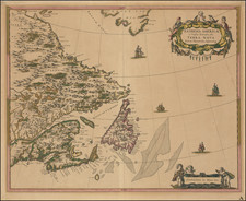
Finely colored example of this working sea chart of Atlantic Canada, from a scarce late edition Van Keulen's 'Zee-Fakkel', the finest Dutch sea chart of the region published during the 18th Century.
The present sea chart embraces the majority of Atlantic Canada, including the entire coastlines of the Gulf of St. Lawrence and all of the territory east of the Gaspé Peninsula. Notably, Newfoundland takes in an exaggerated form, the Avalon and Burin Peninsulas are outsize, while the depiction of the Grand Banks (very well known to European fishermen) is highly detailed. Familiar names include 'St. Iohn' (St. John's, the capital) and 'Plasentia' (Placentia, the capital of the former French colony of Terre-Neuve, ceded to Britain in 1713).
'Cape Brettoon Land' (Cape Breton Island) takes on a roughly familiar form, although it precedes the founding of Louisbourg (established in 1720). The mapping of peninsular Nova Scotia is quite rudimentary, as it does not yet take into account the mapping done for the French Depot de la Marine, first published by Jacques-Nicolas Bellin. However, some familiar names such as 'St. Marguerite' (St. Margaret's Bay) and 'Canso' are included. The east coast of New Brunswick is recognizable, with the indentations of Miramichi Bay and the Bay of Chaleurs, while Prince Edward Island (St. Iohn) takes on a vaguely accurate form. Further north, the Gaspésie and the mouth of the St. Lawrence are depicted in a roughly accurate fashion. To the far southeast, Sable Island, the true "Graveyard of the Atlantic" takes on an exaggerated form, perhaps owing to its outsized threat to Trans-Atlantic shipping.
This scarce chart appeared in a late edition of the Zee-Falkel, volume VI (North America & West Indies), an atlas which was the signature masterpiece of the Van Keulen family, the dominant nautical chart makers in the Netherlands for over 100 years. This particular edition was issued by Johnnes II Van Keulen, based upon a chart designed by his father, Gerard Van Keulen, around 1717. Gerard Van Keulen, in turn, based his chart upon a map of the same title by Nicholas Vissher, published in Amsterdam around 1700. While earlier Van Keulen maps from the 17th Century appear frequently on the market, the later charts, especially those issued after 1750, are very rare, as most copies of the work were used at sea and therefore very few survived.
The Van Keulen chartmaking firm was perhaps the most long-lived dynasty in the history of map publishing, described as "the largest non-governmental hydrographic office in the world." In 1678, the founder of the dynasty, Johannes Van Keulen (1654-1715), established himself in Amsterdam and in 1680 he obtained a patent from the States of Holland and West Friesland permitting him to publish maritime atlases and shipping guides. Van Keulen named his firm 'In de Gekroonde Lootsman' ('In the Crowned Pilot'). Van Keulen employed the cartographer Claes Jansz. Vooght to design his charts. The Nieuwe Lichtende Zee-Fakkel was issued serially in five volumes from 1681 to 1684. Vooght compiled the maps, with artistic embellishments added by Jan Luyken. The Zee-Fakkel was a great commercial success and led the Van Keulen firm to assume a leading role in the European sea atlas trade.
Johannes's son, Gerard Van Keulen (1678-1726), continued his work and produced new editions of the various volumes. In 1755, the head of the next generation, Johannes II Van Keulen (1704-1755), published a new edition of the volume with maps of Asian waters, including the 'Secret Atals' of the Dutch East India Company (the VOC), in 1753. Johannes's great-grandson Gerard Hulst Van Keulen (1733-1801) occupied himself with the last editions of the Zee-Fakkel. The Van Keulen firm operated in various forms until 1885.
Van Keulen's chart is the finest and most interesting Dutch sea chart of Atlantic Canada published during the 18th Century and as such is an essential piece for any serious collection of the cartography of the Maritimes and Newfoundland.
The Van Keulens were a family of chartmakers and publishers. The firm, In de Gekroonde Lootsman (In the Crowned Pilot), was founded in 1678 by Johannes van Keulen (1654-1715). Van Keulen originally registered his business as a vendor of books and instruments (specifically cross-staffs). In 1680, however, he gained a privilege from the States of Holland and West Friesland for the publication of pilot guides and sea atlases.
In that year, van Keulen released his Zee-Atlas (Sea Atlas), which secured him a name in the competitive maritime publishing market. In 1681, he published the first volume of Nieuwe Lichtende Zee-Fakkel (New Shining Sea Torch). This would be the first of an eventual five volumes originally published between 1680 and 1684. A sixth volume was added in 1753. The Zee-Fakel won van Keulen lasting fame. The atlas had charts compiled by Claes Jansz Vooght and artwork from Jan Luyken. It proved immensely popular and was reprinted until 1783. There were translations in French, English, Spanish, and Italian.
The late-seventeenth century was an auspicious time to enter the maritime chart business. Previous industry leaders had either closed shop, died, or retired, leaving space for a new competitor. Van Keulen proceeded to buy up the stock and privileges of several maritime publishing firms; the most notable was the stock of Hendrik Doncker, acquired in 1693.
Johannes’ son, Gerard (1678-1726) took over the business upon his father’s death. Gerard was a skilled engraver and mathematician. His talents were noticed, as in 1706 he was named as Hydrographer to the Dutch East India Company (VOC).
In turn, Gerard’s son Johannes II (1704-1770) came to run the shop. He was also tied to the VOC, and his role as their chartmaker allowed his charts to be considered as quasi-official government documents. It is with access to formerly clandestine VOC geographic knowledge that Johannes the Younger was able to add a sixth volume to the Zee-Fakkel, which covered the East Indies. Johannes also continued to sell instruments, including the recently-invented Hadley’s Quadrant from 1744.
When Johannes II died in 1770, his widow ran the business in his stead, aided by her two sons, Cornelis Buys (1736-1778) and Gerard Hulst (1733-1801). Now a century old, the family business had extended to include an anchor factory. After Cornelis died in 1778, Gerard took on the management of the firm alone. He oversaw the introduction of sextants to their inventory and published the Dutch Nautical Almanac beginning in 1788. Annual editions appeared until 1885. Gerard also served as an original member of the Dutch Commission for Longitude at Sea from 1787.
Gerard’s widow ran the business for nine years after his death, when their son, Johannes Hulst, started to lead the firm in 1810. After his death in 1844, the firm passed out of family hands and into the control of Jacob Swert, a skilled cartographer who had worked for the business for two decades. He passed the work to his son, another Jacob, in 1866. By the mid-nineteenth century, the conversion from sail to steam had diminished the size of the market for charts. Fewer sailors needed fewer maps, charts, and instruments. In 1885, after 207 years in business, In de Gekroonde Lootsman closed its doors and auctioned its stock.


![[The Final State] A New Map of North America, with the West India Islands, Divided according to the Preliminary Articles of Peace, Signed at Versailles, 20 Jan. 1783, wherein are Distinguished The United States and the Several Provinces, Governments &c Which Compose the British Dominions . . . 1794](https://storage.googleapis.com/raremaps/img/small/89085.jpg)