|
||

|

|
|

|
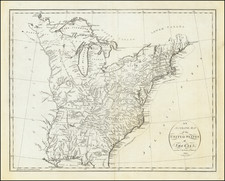
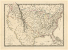
Finely colored example of George Kearsley's rare early map of the United States, engraved by Neele and published in London in 1797.
The map includes a fine treatment of the Indian tribes within the United States, naming dozens of tribes.
The map shows a massive area which appears to be "Tennassee", including Alabama and Mississippi, although erroneously so.
Kentucky and Virginia are shown in particularly unusual configurations.
The treatment of Vermont is also quite unusual, with no northern border.
Sagahadok is shown as a state to the north of Maine. The Territory of Sagahadock, also called the Sagahadoc Colony and New Castle, was an English colonial territory which included the eastern part of what was later colonial Maine and was more sparsely settled than the western region. The area included was east of the Kennebec River.
On some accounts, the English first settled Sagahadoc in 1608-09. A part of the grant of King Charles II in 1664 to his brother the Duke of York, included the territory between the St Croix and Pemaquid and northward, variously called the "Sagadahoc Territory" and "New Castle". The area was later absorbed into the Province of Maine. In 1691, a new charter of Massachusetts was granted by William and Mary and included the Province of Maine, the "territory of Sagadahoc" and also Nova Scotia.
One of the more unusual maps of the United States from the 18th Century.