|
||

|

|
|

|
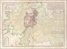
A bright and attractive 1920s pictorial map of Boston, by the prominent graphic artist Charles R. Capon.
This pictorial map captures downtown Boston as it appeared in the 1920s, well before the highway projects of the 1950s divided the city from the waterfront (a problem since remedied by the 'Big Dig'). All of the streets are labeled, while the roofs of houses take on a vibrant red hue. Major sites across town are labeled, including the "State House" on Boston Common, "Paul Revere's House", "The Old North Church", "Faneuil Hall" and "Beacon Hill, Quaint and Charming", amongst others.
The map was issued to celebrate the 75th anniversary of the Boston Five Cents Savings Bank. It was designed by Charles R. Capon (1884-1954), one of America's most prominent graphic artists, who was famous for his custom bookplates.
The map is one of the classic pictorial maps of a major American city, from the great era of the genre that lasted from the 1920s to 1940s.