


|
||

|

|
|

|
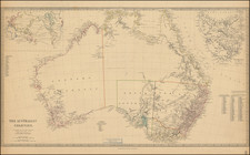
Rare 1859 map of Australia, depicting a very unusual and short-lived interval in the internal territorial evolution of Australia.
This fascinating map shows Australia as it appeared in the early months of 1859, featuring a peculiar combination of interim inter-colonial boundaries. It is one of the only maps to show this arrangement, for it existed for a mere matter of months.
All of the various jurisdictions are distinguished by their own bright colors. The northern boundary of New South Wales (colored in orange) is defined at 26° South, a line which really was only officially observed from February 1846 to April 1847. While this 'ghost boundary' had since been considered the unofficial northern boundary of the New South Wales, it technically did not exist, as all of the northern and central regions of Australia (colored here in yellow) were actually considered to be part of that colony.
This situation would remain the case until June 6, 1859, when the new colony of Queensland was created in northeastern Australia and so moving the northern border of New South Wales considerably further to the south. It seems that the present map was made in the months leading up to the creation of Queensland, when officials in London were still debating the location of the future boundary between New South Wales and its anticipated neighbor to the north.
The other curious feature of the map is that the yellow addition to New South Wales reaches all the way around South Australia (colored in green) to form a narrow strip between Western Australia (colored in pink) and South Australia. This irregular and impractical formation would remain in place until 1860, when the western boundary of South Australia was moved westwards from 132° to 129° East, so as to form a direct border with Western Australia.
Interstingly, Stanford's Library Map of Australasia (1859), a more common map, printed the same year as the present map, features the 'wrap around' of territory around South Australia but not the 'ghost boundary' delineating the northern limits of New South Wales.
In 1863, the part of the yellow territory that lay immediately to the north of South Australia and between Queensland and Western Australia, would become part of South Australia, until it spilt to become the Territory of Northern Australia in 1911.
The map features a large inset of Tasmania, which was only renamed from its original name Van Dieman's Land, in 1856.
The publisher of the map, Edward Stanford, was then on his way to becoming the leading mapmaker of the British Empire. He maintained a close association with the Colonial Office and the Royal Geographic Society, so giving him privileged access to cutting-edge sources and an advantage over his competitors. Importantly, the present map represents Stanford's first of his many maps of Australia.
The present map grants a 'snap-shot' of an unusual and short-lived interval in the internal territorial evolution of Australia. It is also quite rare. We have not been able to trace another example as having appeared on the market since 1990.
Edward Stanford (1827-1904) was a prominent British mapmaker and publisher. A native of Holborn in the heart of London, Edward was apprenticed to a printer and stationer at the age of 14. After his first master died, he worked with several others, including Trelawny W. Saunders of Charing Cross. Saunders oversaw young Edward’s early career, ensuring that he became a Fellow of the Royal Geographical Society. Associations with the Society eventually brought Sanders much business and gave him a reputation as a publisher of explorers. As testament to this reputation, the Stanford Range in British Columbia was named for him by John Palliser.
Stanford briefly partnered with Saunders in 1852 before striking out on his own in 1853. He was an agent for the Ordnance Survey, the Admiralty, the Geological Survey, the Trigonometrical Survey of India, and the India Office. He also controlled the maps of the Society for the Diffusion of Useful Knowledge, another lucrative source of income. In 1857, Stanford founded his namesake Geographical Establishment, with Saunders and A. K. Johnston as engravers. Thereafter, Stanford was known for his “library maps”, particularly those of Africa and Asia.
Addresses and Years of Operation:
- 6 Charing Cross, London (1848): Edward Stanford's initial place of employment at Trelawney Saunders' shop.
- 7 and 8 Charing Cross, London (1853): Stanford expanded his shop to these addresses.
- 55 Charing Cross, London (1873): The shop moved to this larger location.
- 12-14 Long Acre, London (1873): Site of the new print works and current flagship store.
- 7 Mercer Walk, London (2019): Stanfords moved to this address, continuing its legacy.
Stanford's work with Chief Cartographer John Bolton, including the 1858 Library Map of Europe, positioned the company as a leader in quality cartography during a time of exploration and colonialism. Their 1862 Library Map of London earned acclaim from the Royal Geographical Society. With the business thriving, Stanford purchased Staunton & Son in 1877 and, upon retiring in 1885, handed over the reins to his son, Edward Stanford II.
As sole agents for Ordnance Survey Maps, the company's influence and reputation grew, culminating in the Stanford’s London Atlas Of Universal Geography, which was presented to Queen Victoria in 1887. The transition into the 20th century saw further integration of retail, print, and cartographic operations at Long Acre.
During World War I, Stanford's became an essential publisher for the War Office. Edward Fraser Stanford took over in 1917, steering the company through the interwar period and innovations, such as the world’s smallest maps in 1922 and the Daily Mail Motor Road Map in 1926.
Withstanding a bombing in WWII, the company continued under the stewardship of John Keith Stanford and was sold to George Philip & Son in 1947. As it adapted to the digital age, Stanfords received the Ordnance Survey Premier Partner status in 2007 and ventured into online mapping and data services.
Stanfords, now an icon for travellers and explorers, has maintained its cultural relevance and retail success well into the 21st century, underpinned by a legacy of entrepreneurial spirit and commitment to cartographic excellence.
![[ Queensland / Papua New Guinea ] Nouvelle Guinee et Carpentarie](https://storage.googleapis.com/raremaps/img/small/98045.jpg)

![[ Australia ] Das Austral-Continent oder Neu Holland nach Krusentern, King, Flinders, Freycinet, Oxey, Sturt, Mitchell in Mercator's Projection entworfen von C.F. Weiland und Eyre, Frome, Grey, Stokes, Leichardt, und Strzeliecki . . . 1848](https://storage.googleapis.com/raremaps/img/small/95054.jpg)