


|
||

|

|
|

|
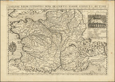
A rare plan of the Siege of Guînes, France, by the great 'Laferi School' mapmaker Paolo Forlani.
This finely engraved battle plan depicts the Siege of Guînes (near Calais, France), in January 1558, following which a French army seized the fortress from an English force. This important event was part of the greater French design to gain control of the Pale of Calais, the last English stronghold on mainland France.
The map was made by Paolo Forlani (fl. 1560-74), one of the leading mapmakers of the 'Lafreri School' of Italian cartography. Originally from Verona, Forlani settled in Venice where he was variously associated with Francesco Camocio, Bolognino Zaltieri and Claudio Duchetti. Forlani's maps of North America, Africa and his World maps are particularly admired.
The present map appeared as part of Forlani's Il Primo Libro Delle Citta, Et Fortezze Principali Del Mondo (Venice, 1567), are rare book featuring plans of contemporary forts and sieges. A subsequent edition of the map appeared in Giulio Ballino's De' Disegni Delle Piu Illustri Citta … (Venice, 1568), published by Zaltieri. It also seems that another edition of the map was issued in Rome, perhaps by Antonio Lafreri, although the circumstances of its publication remain somewhat mysterious; it features a paste-down title and imprint, which reads "Gvines. Ritratto della fortezza di Ghines, pressa per forza de englesi dallo essercito del Re Christianissimo. Formis Romae OODLVIII."
The Siege of Guînes (1558)
By the mid-1550s, the 'Pale of Calais' was the only part of mainland France controlled by England. The strategic port of Calais and its vicinity had been in English hands since the Black Prince defeated the French at the Battle of Crécy in 1346. While England had once controlled vast regions of France during the Medieval Plantagenet period (notably all of Aquitaine), its French territories had been gradually whittled down to only include the Pale. Guînes was an important fortified town and citadel that guarded the southern landward approaches to Calais.
The Habsburg-Valois War (1551-59) pitted France against Spain. England, which was ruled by Queen "Bloody Mary" (reigned 1553-58), became closely allied to Spain, as Mary was married to Spain's Philip II. France, which had always taken great offense to the English "occupation" of the Pale of Calais and its leaders had waited over 200 years to mount a reprise. Late in 1557, France's Henry II dispatched a force of French regulars and German and Swiss mercenaries under his best general, the Duke of Guise, to "repatriate" the Pale.
The English garrison at Guînes was defended by a small force under William Grey, the 13th Baron Grey de Wilton. Guise's force arrived outside of Guînes on December 31, 1557, and began to besiege the town the following day. As shown on the map, the town was set ablaze by the French, while the English held out in the citadel. A key in the upper right details 27 different elements of the action. Guise also simultaneously invested Calais.
Against great odds, Wilton's men fought off the siege for almost three weeks, but on January 19, Wilton was injured by accidentally stepping on a sword. His incapacity demoralized his troops, and the garrison offered to surrender. Guise greatly admired the bravery of Wilton and his men, and offered them very lenient terms. The English were allowed to keep their colors and weapons and were granted safe passage to Dover. The map shows the procession of the English army leaving the citadel. Calais fell on January 22, 1558, and with it, the English presence on mainland France was concluded forever.
All editions of the map are rare. We are aware of only 2 other examples of any of the editions appearing separately on the market during the last 25 years.
Paolo Forlani (fl. ca. 1560-1571) was a prolific map engraver based in Venice. All that is known of his life are his surviving maps and prints, of which there are almost 100 (185 with later states included in the total). He also produced a globe and two town books. It is likely he came from Verona and that he died in Venice in the mid-1570s, possibly of the plague.
![(Geological Map of France) Carte Geologique de la France [4 sheets]](https://storage.googleapis.com/raremaps/img/small/93799.jpg)
![[ France / Roman Gaul ] Galliae Veteris Typus](https://storage.googleapis.com/raremaps/img/small/98777.jpg)
![(Napoleon III) Camp De Chalons - Sur - Marne / Plan du Terrain Affecte au Camp et Des Terrains Environnans Leve par les Officieres du Genie Paris 1857 [with military movements added by hand]](https://storage.googleapis.com/raremaps/img/small/65093op.jpg)