This item has been sold, but you can enter your email address to be notified if another example becomes available.


|
||

|

|
|

|
Stock# 38088
Description
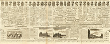
Finely executed map showing the comparative heights of mountains around the world by George Bauerkeller in Darmstadt.
Bauerkeller's maps employ a unique printing process which combines letterpress, color lithography and metal plate printing. His work is quite unique and enjoys an unusual visual appeal. Relatively little is known about Bauerkeller. He is best known for inventing a type of relief printing for city maps called "geomontographie." The city blocks with buildings are raised in white, while streets, squares, parks and rivers are printed in colors.
![Повстанцы 1863 Года [(Polish) Insurgents of 1863]](https://storage.googleapis.com/raremaps/img/small/52719.jpg)
![[Cambodia] Defend the People's Victory | Support the Khmer Rouge & the PRG](https://storage.googleapis.com/raremaps/img/small/85958.jpg)