|
||

|

|
|

|
Stock# 38024
Description
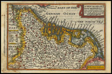
Scarce map of Flanters, published by Kaerius for his Petri Kaerii Germania Inferior id est, XVII provinciarum ejus novae et exactae Tabulae Geographicae, cum Luculentis Singularum descriptionibus additis.
The map covers the region including Ghent, Middelburgh, Brugge, Oostende and Tielt.
Oriented with southeast at the top.
Condition Description
Trimmed to just outside of neatlines.
Old color, but faded.
Old color, but faded.
![[Spa, Belgium]. Plan de Spa, Situe a Sept Lieves de Liege, au Midi, Si Renomme Par Ses Eaux Minerales, dans le quel Sont Designes les Princiapaux Edifices, les Maisons servant de Logement aux Etrangers et les Promenades Publiques](https://storage.googleapis.com/raremaps/img/small/61966.jpg)