
This item has been sold, but you can enter your email address to be notified if another example becomes available.


|
||

|

|
|

|
Stock# 37989
Description
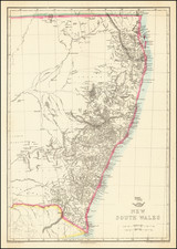
Rare early map of the settlements in New South Wales, from just south of Pt. Denger to Cape Howe, published in London.
Shows the towns, rivers, mountains and harbors in the explored portions of New South Wales, noting the limits of the regions then explored.
The map is quite rare. Tooley notes the 1828 edition, but not this 1824 edition.
Reference
A Guide to Maps of Australia in Books Published 1780-1830: 1824:18.
![[ Australia ] Australien](https://storage.googleapis.com/raremaps/img/small/98068.jpg)
![Neu-Seeland [with] West Australien [with] Tasmania](https://storage.googleapis.com/raremaps/img/small/98073.jpg)