|
||

|

|
|

|
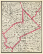
Rare Cold War Soviet spy map of Southern Califonia, extending from Los Angeles to San Diego and Tijuana.
This extraordinary map features coastal Southern California from the metropolitan Los Angeles area down past San Diego to Tijuana. It also shows Catalina, many of the Channel Islands and the adjancent waters of the Pacific Ocean.
Most interestingly, the map was made by the General Staff of the Soviet Army in Moscow, the division in charge, amongst other things, of gathering, printing and selectively disseminating strategically sensitive geographical information to Soviet agents and official departments. The map is precisely copied from a U.S. Topographical survey map, dated 1975, except that all of the text had been translated into Russian Cyrillic.
The Soviet Army issued the present map in 1981, when relations between the Soviet Union and the United States were at their lowest point in almost 20 years, and when the Cold War had noticeably heated up. Leonid Brezhnev authorized the Soviet Invasion of Afghanistan in 1979, causing great consternation in the West, and the American boycott of the 1980 Moscow Summer Olympics. The new U.S. President Ronald Regan, who took office in January 1981, took a hard line aganst the Soviets. The 1980s would see a new arms race between the USSR and America, one which would eventually bankrupt the Soviets and cause the fall of their empire. In the meantime, espionage between Russia and America was on the rise.
It was in this context that this highly detailed and accurate map was made available to a very select audience of Soviet officials, whereupon it had a variety of potential uses. Copies of this map would certainly have been used by military planners to discuss a possible nuclear missile campaign against the United States. It is known that, since the 1960s, the Soviets had dedicated ICBM nuclear missiles in their silos permanently programmed to hit both Los Angleles (due to its status as America's 2nd largest city) and San Diego (due to it being home to the U.S. Navy's main Pacific fleet). Copies of the map must also have been sent to the KGB for planning their innumerable front-line espionage operations in the Los Angeles and San Diego areas. While undercover Soviet spies would not have carried Russian language maps in the field (It would have been really difficult to explain why you had one on your person in 1981, if you were ever searched by American police!), copies of the map would quite plausibly have been used in intelligence planning meetings held at Soviet diplomatic missions within the United States.
Curiously, as an aside, maps are still sensitive issues within Russian-American espionage circles. In May 2012, Colonel Vladimir Lazar of the Russian FSB (the spy service which replaced the KGB), working in the "military-technical department of the general headquarters of the high command" was arrested and sentenced to 12 years of hard labor for spying for the United States. His crime? Selling discs featuring 7,000 scanned maps from Russian security archives to the Americans.
The present map is a truly fascinating original artifact from the Cold War, and a vital aid intended for high-level military strategy and espionge during this tense time in history.
![[Lower California]](https://storage.googleapis.com/raremaps/img/small/25667.jpg)