|
||

|

|
|

|
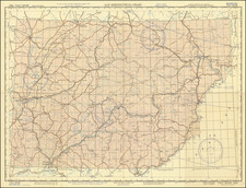
A fine example of an updated edition of the first sea chart of South Korea based on scientific surveys, by the French Dépôt de la Marine.
This fascinating large-format chart of what is now South Korea appeared at a critical time, when the Korean Kingdom was being opened up to foreign trade, and when a variety of world powers competed for influence over the strategic peninsula. It reflects the leading role that the French Navy assumed in the modern mapping of Korea, the Dépôt de la Marine's work being the earliest chart of South Korea to be based on scientific surveys.
The chart embraces the southern half of the Korean Peninsula, up to a point just north of Seoul, roughly comprising the territory of the modern nation of South Korea. Also shown, across the straits is part of the Japanese island of Kyushu and surrounding islands.
The overall outline of the coastlines is highly accurate, and much more so than on previous printed charts. The offshore areas feature copious hydrographic information, including bathymetric soundings, the locations of navigational hazards, and the marking of prominent coastal highlands. Emphasis was placed on approaches to ports that were potentially important for trade, such as the mouth of the Han River, while in other cases, good coaling or revictualing stations were sought out. In many places, such as on the south and east coasts, the quality and intricacy of the surveying is truly impressive.
Curiously, one will notice that in some inshore areas there is very little detail. This is due to the fact that in the 1840s, when most of the surveys on which this chart is based were conducted, foreigners (and especially foreign naval personnel) were essentially forbidden from visiting Korea. While European naval survey vessels sailing off shore, with their superior firepower, could be assured safe passage and the begrudging indulgence of local officials, it was usually too perilous to sail inshore, as running aground could have severe political consequences. For the same reason, some locations have slightly absurd 19th century European names, like "Golfe de l'Imperatrice" (Gulf of the Empress), as having limited contact with the Korean people, the surveyors were generally ignorant of the long-standing Korean nomenclature. Moreover, the charting of the coasts of Korea was pieced together from a variety of different surveys, as the political situation made a systematic survey impossible.
Korea had been ruled since 1392 by the Joseon Dynasty, which with great difficulty had preserved the kingdom's independence against China and Japan. The regime was understandably concerned about the growing presence of Europeans in East Asia, and largely forbade them to visit Korea or for Koreans to have direct contact with Westerners. However, the arrival of Christian books from Japan had caused Christianity to spread rapidly in Korea, and while the government frequently persecuted Christians, this largely proved fruitless. Western culture was permeating Korea, even in the absence of Westerners themselves.
The situation became more acute following the First Opium War (1839-42). The crushing British victory over China (which Korea had long placated by acting as a 'Tributary State') upset the established East Asian political order and emboldened Westerners to increase their presence in the region, even by force if necessary. It was in this context that European surveyors found the opportunity to map the coasts of Korea. The French, in particular, would frequently use the excuse of 'defending Christianity' to interfere in the internal affairs of Korea.
The "Nota" in the middle of the chart describes the various surveys on which the chart is based, although it would also have employed several sources not mentioned. In September 1846, French Admiral Jean-Baptiste Cécille sailed to Korea in order to obtain the release of an imprisoned Korean priest named Andrew Kim Taegon, although the priest was soon executed. However, this afforded Cécille's engineer, Jean de la Roche Poincé, the opportunity to survey significant sections of the west coast of southern Korea. The French vessel Sabine soon followed in its wake, continuing its work on these coasts.
Parts of the southern coasts and the island of Jeju (which the Europeans called 'Quelpart') were surveyed in 1845 by Edward Belcher, a British Royal Navy surveyor aboard the HMS Samarang, who had notably made the first ever survey of Hong Kong in 1841, and who would later go on to be a famous Arctic explorer. Belcher also located the port of Geomun-do off of the south coast of the mainland (called Port Hamilton by Belcher), which would be used as a coaling station by Europeans, and would later become the source of much controversy.
The chart was first issued by the Dépôt de la Marine in 1848, with the newly promoted Roche Poincé, working in the Dépôt's Paris drawing room, given the task of integrating the various surveys into a single chart (he would later become the Chief Engineer of the Dépôt).
Since the first edition was issued, subsequent editions had featured important updates, notably those gained from the surveys of the coasts approaching Seoul conducted by engineers working for Rear Admiral Nicolas-François Guérin, in 1856-7. Guérin had attempted to gain trade concession from the Korean court in Seoul, but was flatly rebuffed. However, he took the opportunity to linger in the area, conducting valuable reconnaissance.
The present edition of the chart was issued in 1887, when Korea was at the center of an epic contest between World powers, including China, Japan, Russia, Britain, France and the United States. It would have been exceedingly useful to French naval vessels and merchant mariners who sought to gain advantage in Korean waters.
In 1853, the American gunboat USS South America had tried unsuccessfully to open up trade with Korea by visiting Busan. In 1866, the Joseon regime executed 8,000 Christians, prompting the French to briefly invade parts of Ganghwa Island (called 'Ile de Kang-Hoa' on the chart), strategically located at the mouth of the Han River, the gateway to Seoul. While the Korean army was defeated by the French troops, it still proved unwilling to make concessions, and the French withdrew. In 1871, the Americans invaded Gangwha Island, and this, in time, caused the Korean court to grant trading privileges to the United States, in 1882.
Korea was opening up to the world, and various foreign embassies were established in Seoul, including those of Russia (1884), Italy (1885), France (1886) and Japan.
In 1887, the year that the chart was made, the British and the Russian navies were competing for dominance over various key ports. Notably, the British had occupied Port Hamilton from 1885 to 1887.
The Sino-Japanese War (1894-5) eliminated China's long-sanding influence over Korea, in favor of an aggressively expanding Japan. Japan was then involved in murdering the Korean Empress Myeongseong who had sought Russian intervention against the Japanese. In 1895, Japan essentially made Korea a client state, and in 1910 annexed the country altogether.
The present example of the chart is augmented by contemporary manuscript sailing tracks and compass measurements in the southern waters. Also, five printed registers of sailing directions are pasted down to the chart's margins. This shows how this important chart was employed by French mariners during this heady period in Korean history.
This chart is a critical monument in the mapping of Korea, being an updated edition of the first sea chart of South Korea predicated on scientific surveys. All editions of the chart are very rare, and we are aware of only a single example appearing at auction in last 25 years, and no listings of other examples in dealers' catalogs during the same period.
The Dépôt de la Marine, known more formally as the Dépôt des cartes et plans de la Marine, was the central charting institution of France. The centralization of hydrography in France began in earnest when Jean-Baptiste Colbert became First Minister of France in 1661. Under his watch, the first Royal School of Hydrography began operating, as did the first survey of France’s coasts (1670-1689). In 1680, Colbert consolidated various collections of charts and memoirs into a single assemblage, forming the core of sources for what would become the Dépôt.
The Dépôt itself began as the central deposit of charts for the French Navy. In 1720, the Navy consolidated its collection with those government materials covering the colonies, creating a single large repository of navigation. By 1737, the Dépôt was creating its own original charts and, from 1750, they participated in scientific expeditions to determine the accurate calculation of longitude.
In 1773, the Dépôt received a monopoly over the composition, production, and distribution of navigational materials, solidifying their place as the main producer of geographic knowledge in France. Dépôt-approved charts were distributed to official warehouses in port cities and sold by authorized merchants. The charts were of the highest quality, as many of France’s premier mapmakers worked at the Dépôt in the eighteenth century, including Philippe Bauche, Jacques-Nicolas Bellin, Rigobert Bonne, Jean Nicolas Buache, and Charles-François Beautemps-Beaupré.
The Dépôt continued to operate until 1886, when it became the Naval Hydrographic Service. In 1971, it changed names again, this time to the Naval and Oceanographic Service (SHOM). Although its name has changed, its purpose is largely the same, to provide high quality cartographic and scientific information to the France’s Navy and merchant marine.
![The Map of China [Huang Ming yitong fang yu bei lan -- Comprehensive view map of the Imperial Ming]](https://storage.googleapis.com/raremaps/img/small/99110.jpg)
![La Tartaria Chinese . . . 1784 [show Corea]](https://storage.googleapis.com/raremaps/img/small/97766.jpg)