


|
||

|

|
|

|
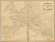
Fine large format map of Europe, published by William Faden, made during the height of the Napoleonic Wars.
This mammoth wall map of Europe captures the Continent in 1804, the same year that Napoleon crowned himself Emperor of France and consolidated his dominance over much of Europe. At this time France was facing Britain, Prussia and the Austrian Empire in a titanic struggle, while many of the other states had been intimidated into being Napoleonic puppet regimes.
As shown, France had already conquered and annexed the Austrian Netherlands (Belgium). In 1796, Napoleon invaded the Republic of Venice, with the consequence that the territories of the 'Serene Republic' were divided between his empire and Austria. Following Napoleon's victory at Marengo (1800), France annexed much of Lombardy and Savoy and had placed a great part of the rest of Italy under de facto French control. Further Italian states, such as Tuscany, would soon become a part of France. The Netherlands, which was at this time the 'Batavian Republic', a French client state, would be swallowed outright by Napoleon in 1806. The multiple German states sandwiched between France and Prussia and Austria lived in constant fear of being overrun by the armies of these great empires.
It was a period of great tension and melodrama, and it appeared that up to this point Napoleon had the upper hand. Britain was seriously concerned about an imminent invasion from France. However, the year following that in which this map was issued saw the Battle of Trafalgar (1805), a crushing British naval victory over France. Napoleon's momentum was dampened, although It would be another decade before the French Emperor would "Meet his Waterloo".
William Faden (1749-1836) was the "Geographer to His Majesty and to His Royal Higness the Prince of Wales", and at the time that this map was issued the leading map publisher in the World. He maintained an uparalleled ability to stay on top of current events, and continually updated his maps to reflect new realities.
This map is a fine full original color example of one of the finest large format maps of Europe published in London at the beginning of the 19th Century.
William Faden (1749-1836) was the most prominent London mapmaker and publisher of the late-eighteenth and early-nineteenth centuries. His father, William Mackfaden, was a printer who dropped the first part of his last name due to the Jacobite rising of 1745.
Apprenticed to an engraver in the Clothworkers' Company, he was made free of the Company in August of 1771. He entered into a partnership with the family of Thomas Jeffreys, a prolific and well-respected mapmaker who had recently died in 1771. This partnership lasted until 1776.
Also in 1776, Faden joined the Society of Civil Engineers, which later changed its name to the Smeatonian Society of Civil Engineers. The Smeatonians operated as an elite, yet practical, dining club and his membership led Faden to several engineering publications, including canal plans and plans of other new engineering projects.
Faden's star rose during the American Revolution, when he produced popular maps and atlases focused on the American colonies and the battles that raged within them. In 1783, just as the war ended, Faden inherited his father's estate, allowing him to fully control his business and expand it; in the same year he gained the title "Geographer in Ordinary to his Majesty."
Faden also commanded a large stock of British county maps, which made him attractive as a partner to the Ordnance Survey; he published the first Ordnance map in 1801, a map of Kent. The Admiralty also admired his work and acquired some of his plates which were re-issued as official naval charts.
Faden was renowned for his ingenuity as well as his business acumen. In 1796 he was awarded a gold medal by the Society of Arts. With his brother-in-law, the astronomer and painter John Russell, he created the first extant lunar globe.
After retiring in 1823 the lucrative business passed to James Wyld, a former apprentice. He died in Shepperton in 1826, leaving a large estate.
![[ Roman Empire ] Imperii Romani Occidentis Scilicet et Orientis Tabula . . . 1779](https://storage.googleapis.com/raremaps/img/small/103241.jpg)