|
||

|

|
|

|
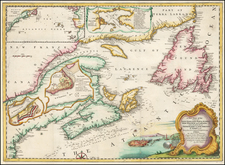
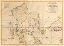
Michael Lane's finely-engraved chart of the southern part of Newfoundland's Avalon Peninsula, the first accurate survey ever taken of these shores, and part of the grand project to chart Newfoundland started by James Cook, with manuscript additions in an old hand.
This excellent sea chart depicts the coasts of the southern part of the Avalon Peninsula, in southeastern Newfoundland. Projecting deep into the Grand Banks, the finest fishing grounds in the world, since the beginning of the 16th Century, the Avalon's harbors had given refuge to fishermen. The main chart extends from Cape St. Mary in the east, thtough the southern coast of the Avalon, and up to Cape Spear, the easternmost point in North America (located just to the south of St. John's). Insets include important fishing harbors: 'Trepassey Bay', 'Shoal Bay Point to Pointe La Haye', 'Brigus Head to Fermouse Harbour', 'Bull Head to Momables Bay'. The coastlines are very carefully delineated, based on trigonometrical surveys and the seas feature copious amounts of hydrograpic information. This chart is the first accurate map of region, and remained the chart of record for mariners for over a century.
Interstingly, this particular example of the chart features old manuscript addtions, in pencil, perhaps added in the early 19th Century. The additions relate to the course of a voyage through the seas off of the south coast of the Avalon Peninsula and rather enigmatically conclude with an overland passage to the port of Trepassey from a nearby cove, suggesting that the vessel in question may have run aground (and had not been able to use the chart effectively!). Two lines are plotted in the seas travelling in a west and northwesterly direction. The upper line reads "Ships course...till 6 PM", whereupon the ship makes at turn heading directly towards the Eastern Head of the Avalon, marks as "Ships Course till 7 1/2 PM", whereupon the sea voyage mysteriously ends, at a point not considered to be a safe anchorage. From Eastern Head leading overland to Trepassey, is another line labelled "Track of the remainder of Ship's Company to Trepassey on the morning of the 24th". This suggests that the ship ran aground and that the passangers had to make an overland journey to Trepassey, a major town where help and provisions could be secured. This theory is further supported by an alternative line running well to the south of the supposedly ill-fated ship's track, which terminates at a point, safely out to sea, noted as "supposed Place at 7 1/2 PM". It seems that due to bad weather or faulty navigational skills the ship ended up much further to the north (and headed on a collision course with rocky shores) than intended. Even with the best sea charts, in this era before modern navigational equipment, such mishaps were commonplace.
The story behind the creation of this chart is fascianting and one of the most consequential in the history of 18th Century cartography. In 1763, Britain had won the Seven Years' War, however, the Treaty of Paris compelled Britain to cede the tiny islands of St. Pierre & Miquelon (located off the southern coast of Newfoundland) to France and to provide the French with limited fishing rights along Newfoundland's shores. The Newfoundland fishery was then big business, in fact, it was annually worth nearly as much as Virginia's tobacco crop, which was Britain's largest single source of revenue from British North American colonies. The British had an imperative to properly manage the fishery (and limit French activities to strictly what was condeded in the Treaty), the problem was, all exisitng charts of Newfoundland's coasts were wildly innacurate. For instance, the contemporary chart of record for the region was Mount & Page's A Chart Shewing Part of the Sea Coast of Newfoundland, from ye Bay of Bulls to Little Placentia Exactly and Carefully Lay'd Down by John Gaudy, first issued in 1715, it as so imprecise as to be scarcely useful.
That year, Admiral Thomas Graves, the Governor of Newfoundland, appointed Lt. James Cook (1728-79) to survey the shores of Newfoundland and southern Labrador. Cook had already won acclaim for his masterly chart of the St. Lawrence River that was used by the British fleet to successfully besiege Quebec City in 1759. However, given the ferocious weather and the exceptional cragginess of Newfoundland's shores, this would prove to be a dramatically more difficult assignment. Fortunately, Cook was assisted by Michael Lane (fl. 1763-84), a highly competent surveyor who refined his skills ot the highest levels under Cook's mentorship.
The Newfoundland survey proceeded expeditiously until 1767, when Cook was appointed by the Admiratly to lead the first of the three Pacific Voyages that would make him the foremost explorer of the 18th Century. The superlative quality of the surveys already sent back to England, combined with glowing reports from Cook's superiors had been responsible for this august appointment. From that point onwards, Lane was left to lead the project to survey Newfoundland on his own. Fortunately, Lane had by this time refined his surveying skills, such that they were very near or even equal to the loftly standards set by Cook.
Lane conducted the present survey of the southern shores of the Avalon Peninsual in 1773, with the manuscript chart being quickly dispatched to London for publication by the firm of Jefferys & Faden. The chart is very finely engraved, commensurate with the high standards employed by William Faden (1749-1836), soon to become the leading mapmaker of the British Empire.
All considered, Cook and Lane's Newfoundland surveys are viewed as one of the most impressive achievements of cartography during the 18th Century. How they managed to accurately capture the complexity of Newfoundland's coastlines should still impress the modern day observer. So accurate were the charts, that the Admiralty did not see any need to resurvey Newfoundland's shores until 1871! Cook and Lane's original manuscript charts are today preserved at the U.K. National Achives (Kew).
The present chart is rare and seldom appears on the market. We are aware of no examples appearing in dealers' catalogs over the last 25 years. The chart was sold both separately and included in The North American pilot for Newfoundland, Labradore, the Gulf and River St. Laurence : being a collection of sixty accurate charts and plans, drawn from original surveys (London: Sayer & Bennett, 1777), a rare sea atlas of Atalntic Canada.
Thomas Jefferys (ca. 1719-1771) was a prolific map publisher, engraver, and cartographer based in London. His father was a cutler, but Jefferys was apprenticed to Emanuel Bowen, a prominent mapmaker and engraver. He was made free of the Merchant Taylors’ Company in 1744, although two earlier maps bearing his name have been identified.
Jefferys had several collaborators and partners throughout his career. His first atlas, The Small English Atlas, was published with Thomas Kitchin in 1748-9. Later, he worked with Robert Sayer on A General Topography of North America (1768); Sayer also published posthumous collections with Jefferys' contributions including The American Atlas, The North-American Pilot, and The West-India Atlas.
Jefferys was the Geographer to Frederick Prince of Wales and, from 1760, to King George III. Thanks especially to opportunities offered by the Seven Years' War, he is best known today for his maps of North America, and for his central place in the map trade—he not only sold maps commercially, but also imported the latest materials and had ties to several government bodies for whom he produced materials.
Upon his death in 1771, his workshop passed to his partner, William Faden, and his son, Thomas Jr. However, Jefferys had gone bankrupt in 1766 and some of his plates were bought by Robert Sayer (see above). Sayer, who had partnered in the past with Philip Overton (d. 1751), specialized in (re)publishing maps. In 1770, he partnered with John Bennett and many Jefferys maps were republished by the duo.
William Faden (1749-1836) was the most prominent London mapmaker and publisher of the late-eighteenth and early-nineteenth centuries. His father, William Mackfaden, was a printer who dropped the first part of his last name due to the Jacobite rising of 1745.
Apprenticed to an engraver in the Clothworkers' Company, he was made free of the Company in August of 1771. He entered into a partnership with the family of Thomas Jeffreys, a prolific and well-respected mapmaker who had recently died in 1771. This partnership lasted until 1776.
Also in 1776, Faden joined the Society of Civil Engineers, which later changed its name to the Smeatonian Society of Civil Engineers. The Smeatonians operated as an elite, yet practical, dining club and his membership led Faden to several engineering publications, including canal plans and plans of other new engineering projects.
Faden's star rose during the American Revolution, when he produced popular maps and atlases focused on the American colonies and the battles that raged within them. In 1783, just as the war ended, Faden inherited his father's estate, allowing him to fully control his business and expand it; in the same year he gained the title "Geographer in Ordinary to his Majesty."
Faden also commanded a large stock of British county maps, which made him attractive as a partner to the Ordnance Survey; he published the first Ordnance map in 1801, a map of Kent. The Admiralty also admired his work and acquired some of his plates which were re-issued as official naval charts.
Faden was renowned for his ingenuity as well as his business acumen. In 1796 he was awarded a gold medal by the Society of Arts. With his brother-in-law, the astronomer and painter John Russell, he created the first extant lunar globe.
After retiring in 1823 the lucrative business passed to James Wyld, a former apprentice. He died in Shepperton in 1826, leaving a large estate.