|
||

|

|
|

|
Extremely Rare - one of the earliest obtainable separately issued maps of Dallas, Texas, Murphy & Bolanz's highly detailed promotional broadside.
This fascinating map is a promotional broadside, extolling the virtues of Dallas, Texas as "the Commercial Emporium of Texas," published by Murphy & Bolanz in 1888 (the map portion itself is dated 1887, while the accompanying text is dated June 1888).
The map consists of a reduced copy of a larger map by Murphy & Bolanz, printed on a sheet with extensive promotional text, entitled: Dallas Texas. Facts and Figures Pertaining to a Busy and Progressive City. Her Wonderful Growth, Vast Resources and Healthy Financial Condition.
The real estate firm of Murphy & Bolanz, was one of the first regular publishers of promotional maps of the City of Dallas. The firm, founded in 1874, was then one of the prime movers in the city and still exists to this day as Bolanz & Miller.
Historical Context
Dallas was one of the great American 'boom towns' of the late 19th Century, and developed rapidly from a small frontier outpost into Texas' most dynamic city. The present map was made at the apex of this exciting period.
What would later be known as Dallas was founded in 1839 by the trader John Neely Bryan, who recognized the site's strategic value, located near one the few fords along the Caddo Trail, along the Trinity Floodplain. Bryan built a trading post and conducted the first survey of the area.
In 1841, a treaty process removed all Native Americans from the Dallas region, thus eliminating most of Neely's customers. He then decided to shift gears and establish a permanent town.
J. P. Dumas surveyed and laid out a 0.5 square mile town site in 1844, which formed the genesis of modern Dallas' distinct grid street system. Dallas' importance was enhanced upon Texas' annexation to the United States, in 1845, as it acted as a natural nexus between the populated areas of southern Texas and the American territories located to the north and east. It was around this time that the settlement was named 'Dallas' almost certainly after George Dallas, who served as the Vice-President of the United States from 1845 to 1849.
In 1856, Dallas was granted a town charter by the Texas Legislature. By 1860, its population reached 678, including 97 African Americans and many recent European immigrants. Also, by this time, several key stage lines ran through the city and the railroad was in the process of being built towards Dallas from the south.
Dallas was spared any direct involvement in the U.S. Civil War (1861-5) and unlike most other Southern cities flourished during the Reconstruction Period.
By 1871, Dallas's population exceeded 3,000 and its city charter was officially ratified.
In 1873, Dallas became the intersection of the Houston & Texas Central Railroad and the Texas & Pacific Railway, thus ensuring its role as a major transport hub. The city soon became one of the main clearinghouses for Texas's agricultural goods and was the last 'civilized' stop for many Americans travelling to the Southwest. Dallas' population soared racing over 10,000 by 1880.
Unsurprisingly, Dallas became one of the hottest real estate markets in America and vast fortunes were made by those who correctly anticipated the rail routes and the sites where innumerable businesses sprang up in the area. The makers of the preset map, Murphy & Bolanz, were amongst the leading players in real estate speculation during this period, and this map was intended as a propaganda piece to encourage more migration to the city and to gin up property prices.
Dallas' importance was further enhanced in 1880 by the completion of the Missouri-Kansas-Texas Railroad, under the leadership of Jay Gould. Growth accelerated, and by the time that this map was made, Dallas had a population of around 35,000.
In the late 1880s Dallas real estate firms, like Murphy & Bolanz, would barely have had a chance to list properties before they were snapped up, at ever higher prices. This created a massive 'Property Bubble' which burst during the Panic of 1893, a nation-wide recession. While Dallas would recover, the Panic had the effect of introducing an element of sobriety to Dallas' economic life.
The Rarity of the Present Map
The map is of the utmost rarity. We note an example at the New York Public Library, but not copies in Texas institutions.
The earliest printed maps of Dallas which are noted on OCLC are:
• Jones & Murphy's map of the city of Dallas, Texas (1878)
• Murphy and Bolanz's Official map of the city of Dallas (1887, 1888 and 1891 editions).
Additionally, we offered an example of the 1882 Jones & Murphy map of Dallas in 2012:
www.raremaps.com/gallery/detail/28590
The Library of Congress has only one map in its on-line collection that predates the present map. Phillips and Day do not list any maps of Dallas from before 1900.
The present map is one of the most detailed impressions of the city from its formative 1872 to 1893 boom period and, especially given its rarity, is a highly important artifact relating to the history of Dallas.
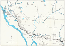
![[ Texas - Geology ] Erforschung von Nordwest-Texas durch D. O. Lowe & A.R. Roessler 1872 (with) Orientirungskarte . . . 1873](https://storage.googleapis.com/raremaps/img/small/96578.jpg)