This item has been sold, but you can enter your email address to be notified if another example becomes available.


|
||

|

|
|

|
Stock# 37783
Description
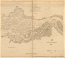
Scarce chart of the Columbia from Point Adams and Cape Disappointment to Fort Vancouver.
Shows 10 Indian Villages, several forts, soundings throughout the river and the hut where Lewis & Clark wintered near Young's Bay and Ft. George.
Two profiles also shown. An important early Oregon Territorial map.

![Pacific Coast Highways Canada to Mexico [Texaco Tour Maps Routes and Mileages Canada to Mexico]](https://storage.googleapis.com/raremaps/img/small/91594.jpg)