|
||

|

|
|

|
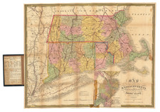
Important early broadside map and plan of the Battle of Bunker Hill and the area around Boston, published by Sayer & Bennett, in London in 1775.
Sayer & Bennett's map of the Seat of War is one of the two earliest pictorial accounts of the Battle of Bunker Hill, preceded only by Jeffeys & Faden's A Sketch of the Action between British Forces and the American Provincials on the Heights of the Peninsula of Charlestown, which provides only a small simplistic model of the troop movements and placements around the battle site. Prepared to inform the British public of the totality of the Theater of War and the British Victory, Sayer & Bennett's work is without question the best pictorial account of the conflict.
Believed to have been based upon a letter from a June 25, 1775 letter from General Burgoyne to Lord Stanley (which Sayer & Bennett later published separately as a broadside), the map provides a dramatic account of the Battle, including an inset showing Charlestown under attack by British forces, with the town in flames as British warships bombard it from the water, and a British battery shelling the town from across the Charles River.
The map is credited to "an American volunteer," and it is among the most accurate maps of the period from an American perspective. The movement of colonial troops to Boston, including Washington's army and the New Hampshire Rangers, is outlined on the principal map with minute figures of troops, horses, and cannon. The vivid inset battle-plan, based on John Norman's engraving, shows Charlestown in flames.
Sayer & Bennett's broadside map consists of three maps from two engraved plates printed on one sheet. The larger map is based on Thomas Jeffreys' " Inhabited part of New England. . . ." and includes an overview Southeastern New England showing the convergence of American troops from New Hampshire, Connecticut and Rhode Island towards Boston, along with Washington's route from New York bringing troops and artillery, which proved decisive in the battle. Two insets, one of the harbor and one of the city of Boston and the Charlestown peninsula with a depiction of the Battle of Bunker's Hill. The smaller inset in the upper right is a plan of Boston Harbor.
Robert Sayer (ca. 1724-1794) was a prominent London map publisher. Robert’s father was a lawyer, but his older brother married Mary Overton, the widow of prominent mapmaker Philip Overton and the proprietor of his shop after his death. Mary continued the business for roughly a year after her marriage and then, in early 1748, it passed to Robert. Robert became a freeman of the Stationers’ Company later that year; his first advertisement as an independent publisher was released in December.
Sayer benefited from Overton’s considerable stock, which included the plates of John Senex. In the 1750s, Sayer specialized in design books and topographical prints, as well as comic mezzotints. In 1753, he, along with John Roque, published a new edition of Thomas Read’s Small British Atlas, the first of several county atlases that Sayer would publish.
Sayer’s business continued to grow. In 1760 he moved further down Fleet Street to larger premises at 53 Fleet Street. In 1766, he acquired Thomas Jefferys’ stock when the latter went bankrupt. In 1774, he entered into a partnership with John Bennett, his former apprentice. The pair specialized in American atlases, based on the work of Jefferys. They also began publishing navigational charts in the 1780s and quickly became the largest supplier of British charts in the trade.
Bennett’s mental health declined, and the partnership ended in 1784. As Sayer aged, he relied on his employees Robert Laurie and James Whittle, who eventually succeeded him. He spent more and more time at his house in Richmond. In 1794, he died in Bath.
John Bennett (fl. 1760-d. 1787) was a London printer best known for his role in the successful partnership of Sayer & Bennett. In 1760, Bennett became a servant of Robert Sayer (ca. 1724-1794), the prominent print and map seller, and was apprenticed to him in 1765. In 1774, Bennett became a free journeyman and entered into a partnership with Sayer. They issued joint advertisements and publications. In 1777, Bennett owned 1/3 share in the business. The partnership was likely to continue fruitfully, but in 1781 Bennett began to show signs of mental illness. In 1783, he was admitted to an asylum for nine months and, in 1784, Sayer filed papers to dissolve their business partnership. Bennett died in 1787.
![[ Large Cape Cod Inset ] The River & Gulf of St. Lawrence, Newfoundland, Nova Scotia, and The Banks Adjacent, From The English Admiralty & French Marine Surveys. . . . 1844. Additions To 1857.](https://storage.googleapis.com/raremaps/img/small/85637.jpg)
![(American Revolution) [Manuscript Map of New York City and Northern New Jersey]](https://storage.googleapis.com/raremaps/img/small/69609.jpg)
![[A chart of New York Island & North River: East River, showing passage through Hell Gate, and the North Shore of Long Island: Flushing Bay, Hampstead Bay, Oyster and Huntington Bay, Cow Harbor]](https://storage.googleapis.com/raremaps/img/small/51531.jpg)