|
||

|

|
|

|
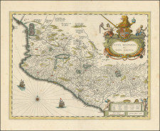
Rare miniature map of Mexico or New Spain, hand colored by regions, from one of John Seller's miniature atlases.
This example is the first state of the map, published in 1685. The map is most probably from Seller's New Systeme of Geography first issued in 1685, although it could also be from a re-issue of the Atlas Terrestris.
John Seller, Sr. was not only an instrument maker, surveyor, cartographer, artist and Hydrographer to the King and Queen, but moreover he was responsible for the first English Pilots. which were continually reprinted and still in use centuries after his death in 1697. He produced charts and atlases, navigational aids, almanacs, celestial maps, as well as Pilots, and should perhaps be remembered first and foremost for his major contribution to the maritime world of sailing and navigation.
Seller was appointed Hydrographer by Charles II in 1671, and also served under James II and William III. As the King's Hydrographer, Seller was granted a 30-year privilege giving him a monopoly on publishing nautical atlases in England. Over his long career, Seller published a variety of titles, often in numerous editions, such as Praxis Nautica, or Practical Navigation (1669); Atlas Maritimus (1669); An epitome of the art of navigation (1681); and Atlas Terrestris (1676). While his maps often lack beauty and finesse, Seller contributed significantly to English cartography by helping to establish the market for English-language maps and charts and encouraging the growth of the cartographic industry in 17th Century England.
John Seller was one of the most notable map and instrument makers in England in the late-seventeenth century. He was especially known for the sea charts, many of which featured in his influential English Pilot and Atlas Maritimus. Seller was born in London in 1632. His father was a cordwainer and John was apprenticed to Edward Lowe, of the Merchant Taylors’ Company. He was made free of that company in 1654. Later, he also was made a brother of the Clockmakers’ Company, which housed several instrument makers. He started business as a compass maker but expanded his offering to include navigational instruments and charts.
Seller’s career was halted temporarily, and fantastically, when he was tried for high treason in 1662. He was accused of involvement in a plot led by Thomas Tonge. While Seller likely only unwisely repeated rumors, he was convicted. The other conspirators, who did admit some degree of guilt, were executed, but Seller maintained his innocence and, via insistent petitions, he eventually secured his release from Newgate Prison.
This episode did not seem to slow Seller’s rise too much, however. Seller was granted a royal license to publish English-language maritime atlases. This gave him a near-monopoly and led to his being named hydrographer to the King in 1671. Although the point of the project was to produce English charts of Dutch dominance and bias, Seller ended up using many Dutch plates as his base material. The first volume of The English Pilot was published in 1671, followed by more volumes as well as The Coating Pilot (1672) and the Atlas Maritimus (1675). Seller was commercially successful, but some of his projects required further support. The English Pilot was eventually taken over by John Thornton and William Fisher, for example, and his proposed English atlas only produced maps of six counties.
Seller’s sons, John and Jeremiah, followed in their father’s profession. Seller also apprenticed several promising young men, including Charles Price, with whom his sons partnered. Through Price, Seller can be seen as the founding figure of an important group of London mapmakers that included Price, John Senex, Emanuel Bowen, Thomas Kitchin, and Thomas Jefferys.

![(Aztec Tribute List) [Original watercolor showing tribute items paid to the Aztecs by subject towns] Mendoza Col. part 1s Lorenzana, Aglio 1, Vol 22...](https://storage.googleapis.com/raremaps/img/small/102321.jpg)
![[Jefferson's Notes on the State of Virginia] Observations sur la Virginie [with the map:] A Map of the country between Albemarle Sound, and Lake Erie, comprehending the whole of Virginia, Maryland, Delaware, and Pensylvania, with parts of several other of the United States of America. Engraved for the Notes on Virginia.](https://storage.googleapis.com/raremaps/img/small/51828.jpg)