|
||

|

|
|

|
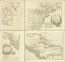
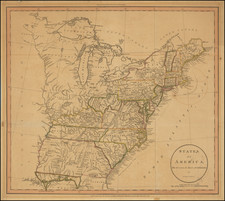
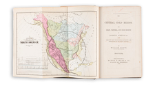
Scarce early map of the United States, issued just prior to the creation of the Republic of Texas in 1836.
Marvelous large format map of the United States. The map includes a marvelous treatment of the Western Territories of the United States, including a massive Neu-Californien, Tomahawk shaped Indian Territory, large "Oregan" Territory, extending to the Rocky Mountains, and large Missouri Territory, pre-dating the appearance of Nebraska Territory, Kansas, etc.
Upper California is shown in great detail, immediately before the explorations of John Fremont would eliminate the cartographic myths of the two large salt lakes (Timanagos and Teguayo) and the river systems connecting each to the Pacific Ocean. In fact, this map is one of the most remarkably clear and bold depictions of these two mythical lakes and rivers, showing side by side with a relatively accurate and modern depiction of the Upper Colorado River, which had been explored for many years by Spanish missionaries, offering a stark contrast of the semi-explored regions of the West and those which were still virtually unknown.
In Oregon Terrtory, the river systems reflect the explorations of Lewis & Clark, the Hudson Bay Company outposts, etc.
The map is apparently quite scarce, this being the first example we have seen in nearly 20 years.