|
||

|

|
|

|
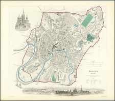
Fine early view of Konigsberg (Kalingrad), first published by Braun & Hogenberg in 1581.
The following is a translation of the text on verso:
Königsberg in Prussia is a most noble and famous city, which was founded in the year 1254 by the Teutonic Knights. Alongside their artisan activities, the citizens engaged first and foremost in maritime trade. They thereby dealt in grain, solid and liquid pitch, which the Germans call resin, as well as salt, flax, hemp, wax, wood and also in a great deal of honey and mead; this is a sweet drink that is made from honey and comes from Livonia.
Königsberg's location on the Pregel, shortly before it reaches the Vistula Lagoon on the Baltic Sea, is shown on Braun & Hogenberg's view from the south. The river separates the town of Kneiphof on the island from the Old Town (above) and the town of Löbenicht (in the west). With the founding of the Old Town in 1254 by the Teutonic Knights, the two other towns also sprang up, but remained independent until 1724.
Within Königsberg proper, the Old Town church (Alt Steter Pfarkirch) can be seen on the left and, beside it to the right, the palace of the Teutonic Knights (Schlos) with its tall tower (Schlos thurn). In 1457 Königsberg became the primary residence of the Grand Master of the Teutonic Knights and in 1525 was incorporated into the Duchy of Prussia. On the Island of Kneiphof lie Königsberg cathedral and on the right the Albertina University (Collegium), founded in 1544 by Albert I, Duke of Brandenburg.
Georg Braun (1541-1622) was born and died in Cologne. His primary vocation was as Catholic cleric; he spent thirty-seven years as canon and dean at the church St. Maria ad Gradus, in Cologne. Braun was the chief editor of the Civitates orbis terrarum, the greatest book of town views ever published. His job entailed hiring artists, acquiring source material for the maps and views, and writing the text. In this role, he was assisted by Abraham Ortelius. Braun lived into his 80s, and he was the only member of the original team to witness the publication of the sixth volume in 1617.
Frans Hogenberg (ca. 1540-ca. 1590) was a Flemish and German engraver and mapmaker who also painted. He was born in Mechelen, south of Antwerp, the son of wood engraver and etcher Nicolas Hogenberg. Together with his father, brother (Remigius), uncle, and cousins, Frans was one member of a prominent artistic family in the Netherlands.
During the 1550s, Frans worked in Antwerp with the famous mapmaker Abraham Ortelius. There, he engraved the maps for Ortelius’ groundbreaking first atlas, published in Antwerp in 1570, along with Johannes van Deotecum and Ambrosius and Ferdinand Arsenius. It is suspected he engraved the title page as well. Later, Ortelius supported Hogenberg with information for a different project, the Civitates orbis terrarium (edited by Georg Braun, engraved by Hogenberg, published in six volumes, Cologne, 1572-1617). Hogenberg engraved the majority of the work’s 546 prospects and views.
It is possible that Frans spent some time in England while fleeing from religious persecution, but he was living and working in Cologne by 1580. That is the city where he died around 1590. In addition to his maps, he is known for his historical allegories and portraits. His brother, Remigius, also went on to some fame as an engraver, and he died around the same time as his brother.
![Plan eines Regulairen Laagers [Plan of a Regular Camp]](https://storage.googleapis.com/raremaps/img/small/93734.jpg)
![[ Brandenburg & Pomerania ] Tabula Electoratus Brandenburgici, Meckelenburgi et Maximae Partis Pomeraniae . . . 1630](https://storage.googleapis.com/raremaps/img/small/99232.jpg)