


|
||

|

|
|

|
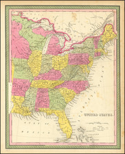
A fascinating publisher's proof of Buchon's important map of the Untied States, with an experimental coloring scheme and original editorial notes.
This is unique publisher's proof of Jean Alexandre Buchon's important map of the United States, intended to be included in his Atlas geographique, statistique, historique et chronologique des deux Ameriques (Paris, 1825). It was evidently made for the publisher of the work, J. Carez, and the manuscript notes, quite possibly in the hand of Buchon, detail of how the map was to be colored. The original 13 states, plus Vermont, were to take on a pink hue; Florida (acquired by the U.S. from Spain in 1819) was to assume on a teal hue; the states and territories in the Trans-Appalachian west (unorganized land conferred to the U.S. by Britain in 1783) were to be in a green hue, and the western territories, beyond the Mississippi, were to assume a yellow hue. The nature of the coloring was integral to the purpose of the map. The splotches and irregular lines of color around the map were intended to test the appearance of the color as it was applied to the paper.
Bouchon's map is interesting in that it shows the development of the United States two generations after the American Revolution. Each of the states and territories are marked, naming their capitals, noting the dates of their entry into the Union and giving statistics as to their populations and geographic size. By 1825, many of the lands east of the Mississippi had already been divided into states, although the Northwest Territory still exits. The vast Louisiana Territory, purchased from France in 1803, occupies the vast lands between the Mississippi and the Rockies, although the states of Louisiana and Missouri have been constituted. The Oregon Territory is shown occupy the Pacific Northwest, although the ownership of this region was officially still shared between the United States and Britain.
Buchin derived the style of his maps from the signature cartographic style pioneered in Henry Charles Carey & Isaac Lea's American Atlas (Philadelphia, 1822).
The present example is an intruiging artifact lending unique insight into the map-publishing process during the early 19th Century.
Jean Alexandre Buchon (1791-1849) was a French scholar and historian. Born as the French Revolution raged, Buchon was dedicated to recovering France’s history in order to help the country heal and grow. He gathered French stories and published them as part of Collection des chroniques nationales franciases ecrites en langue vulgaire, du XIe au XVIe siècle (4 vols, 1824-1829). He also compiled and published an exploration collection and several histories, particularly about medieval France.
For geography, his most important contribution was publication of the French edition of Carey & Lea’s American Atlas in 1825. Each page of the atlas includes highly detailed text about the state or territory depicted, as well as a map of the area. The French edition is generally considered in high regard as compared to other editions, as it has quality paper and superior engraving.
![Colton's United States of America [State of Colona named]](https://storage.googleapis.com/raremaps/img/small/90086.jpg)
![[ First Gold Rush Edition! ] Colton's Map of the United States of America, The British Provinces, Mexico, The West Indies and Central America . . . 1849](https://storage.googleapis.com/raremaps/img/small/101951.jpg)
![[All The Way With LBJ - 1964 Presidential Election Campaign Poster] Johnson Humphrey for the USA](https://storage.googleapis.com/raremaps/img/small/88907.jpg)
![[First State of the Popple Key Sheet] A Map of the British Empire in America with the French and Spanish Settlements adjacent thereto by Hen. Popple.](https://storage.googleapis.com/raremaps/img/small/92714.jpg)