|
||

|

|
|

|
A facinating World War II map printed in British India, depitcting the state of affairs on the Russian/Ukraine Front as they developed up to the spring of 1944.
The map depicts, among other things, the Soviet Russian retaking of the Crimea from Nazi Germany, a topic which finds currency 70 years later in 2014.
This interesting map depicts all of Central and Eastern Europe, with a focus on the Soviet Union. Issued during the spring of 1944, it depicts the present and former state of affairs along the Eastern European Battlefront. As shown on the map, the dotted line annotated as the "Russian Line, June 22 1941" shows the border between Nazi--held areas and Russian domains, as prescribed by the Molotov-Ribbentrop Pact of 1939 (whereby Germany and the Soviet Union agreed to cooperate and divide Poland between them). The "Russian Line of Sept. 1, 1939" shows the previous Soviet western boundary, before it moved to take in part of Poland.
In the spring of 1941, Germany decided to forsake the pact, and on June 22, 1941, mounted a powerful military assault against the Soviet Union, popularly known as the Barbarossa Offensive. While the going was hard, Germany made progress, pushing deep into Soviet territory, to the gates of Lenningrad and to the western banks of the Volga River.
However, by the summer of 1942, the Germans became bogged down, holding massive amount of enemy territory, with dwindling supplies and weakening supply lines. During the Battle of Stalingrad (at Volgagrad, located just off of the map to the east), which lasted 5 months from August 1942 to February 1943, the Soviets finally managed to turn the tide, and from that point on they made steady gains against the Germans. The jagged "Battle Line of October 15, 1943" shows how the line had moved west around 8 months later. The line located further west, "Battle Line, April 5, 1944" shows how the Germans had been pushed out of Crimea and west to a point in the western Ukraine. This is how the state of affiars had developed up to the time that this map was made. The fighinting would continue on the European Eastern Front until the Russians seized Berlin in early May 1945.
The map was issued in British India at the height of World War II, likely at the instigation, and certainly with the blessing of the colonial government, as a propaganda piece to educate readers on the Allied progress in the greater War.
The present map is very rare. It was printed in small quantities by a press in India (perhaps Calcutta) and issued to British officers, officials and interested native Indians. As it was viewed as an ephemeral piece for temporary use, almost all examples would have been discarded, making this example a rare survivor.
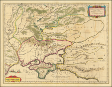
![[Crimea / Ukraine Battle Map ] Charte der Kriegs Operationen am Donn und Dniepr Ihro Russisch Key Serl: Maiest: Glorieusen Armeen A: 1736 gestorchen bey der keyserl: Acad: der Wissensch: in St. Petersb.](https://storage.googleapis.com/raremaps/img/small/101811.jpg)
![[ Tsar Alexander II ] Alexander II Kaiser von Russland](https://storage.googleapis.com/raremaps/img/small/91242.jpg)
![(Second World War - Eastern Front - Siege of Sevastapol) [Hand-Annotated Map of the Siege of Sevastapol]](https://storage.googleapis.com/raremaps/img/small/89089.jpg)