This item has been sold, but you can enter your email address to be notified if another example becomes available.


|
||

|

|
|

|
Stock# 37526
Description
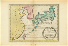
Striking early map of Japan and Korea.
Briet's map follows the Blancus/Moreira model, and looks very similar to the Christophoros Blancus unpublished map of 1617. The map shows a well-shaped Japan with named provinces, and major cities including Tokyo (Yendo) and Kyoto (Meaco). Kyushu and Shikoku are shown with exaggerated inlets, and the tip of Hokkaido is Terre de Iesso. Korea is described as an island, but is only partially shown.
Reference
Walters #32, OAG 31; Cortazzi, Isles of Gold #67.
![[Comprehensive Map of China] 支那全圖 Shina zenzu](https://storage.googleapis.com/raremaps/img/small/65521.jpg)
![Carte des nouvelles decouvertes dresseee par Phil. Buache… [with] Extrait d'une Carte Japonoise de l'Univers apportee en Europe par Kaempfer . . . [Bay of the West]](https://storage.googleapis.com/raremaps/img/small/84038.jpg)
![[ China ] L'Empire De La Chine dresse d'apres les Cartes de l'Atlas Chinois . . . 1751](https://storage.googleapis.com/raremaps/img/small/90831.jpg)