


|
||

|

|
|

|
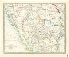
Fourth edition of this rare Indian Wars map of Montana Territory, prepared by order of Major General W.S. Hancock.
Prepared for General Winfield Scott Hancock in prosecution of the Sioux Indian Wars, the map shows battle sites and military expeditions. First issued in May,1872 by Captain D.P. Heap, the map went through 4 editions, being later revised in May 1875 by Captain William Ludlow and in 1878 by Lieutenant Edward Maguire and Private Julius J. Durage and again by Maguire & Durage in 1881.
This uncolored map covers all of Montana Territory, with small areas in the adjoining Idaho, Utah, Wyoming, and Dakota Territories. It is noteworthy for its excellent topographic detail. Among the key features of this map is that it shows both the locations of Indian reservations and tribes and the routes of the various army expeditions and explorations in the territory through 1880. These routes include General George A. Custer's route in 1876 to the Little Big Horn. Fort Custer, established and named in 1877, is shown with extensive details and notations in that area. The map was periodically updated to show additional information as the Indian Wars continued, making this 1881 edition the most complete of the 4 editions, in terms of its inclusion of content from the various military expeditions against the Sioux.
The map includes all of Yellowstone National Park, with some detail, along with other lands in northern Wyoming. Particularly well-depicted is the area around the Big Horn Mountains which extend across Montana and Wyoming. Issued in the year of Sitting Bull's surrender, this map provides a marvelous snapshot of the region at the conclusion of the last of the major Indian campaigns conducted by the United States against the Native American Tribes.
Winfield Scott Hancock (1824 - 1886) was a career U.S. Army officer and the Democratic nominee for President of the United States in 1880. He served with distinction in the Army for four decades, including service in the Mexican-American War and as a Union general in the American Civil War. Known to his Army colleagues as "Hancock the Superb", he was noted in particular for his leadership of II Corps at the Battle of Gettysburg in 1863, playing a major role on all three days of the battle. His military service continued after the Civil War, as Hancock participated in the military reconstruction of the south and the Army's presence at the western frontier.
After the Civil War, Hancock supervised the executions of the Lincoln assassination conspirators. Thereafter, Hancock was assigned command of the newly organized Middle Military Department, headquartered in Baltimore. In 1866, on Grant's recommendation, Hancock was promoted to major general and was transferred to command of the military Department of the Missouri, which included the states of Missouri, Kansas, Colorado, and New Mexico. Hancock reported to Fort Leavenworth, Kansas, and took up his new posting. Soon after arriving, he was assigned by General Sherman to lead an expedition to negotiate with the Cheyenne and Sioux, with whom relations had worsened since the Sand Creek massacre. The negotiations got off to a bad start, and after Hancock ordered the burning of an abandoned Cheyenne village in central Kansas, relations became worse than when the expedition had started. There was little loss of life on either side, but the mission could not be called a success.
Hancock was briefly re-assigned to New Orleans and placed in charge of the Fifth Military District. Following General Ulysses S. Grant's 1868 presidential victory, Hancock was transferred to the Department of Dakota. The Department covered Minnesota, Montana, and the Dakotas. As in his previous western command, Hancock began with a conference of the Indian chiefs, but this time was more successful in establishing a peaceful intent. Relations worsened in 1870, however, as an army expedition committed a massacre against the Blackfeet. Relations with the Sioux also became contentious as a result of white encroachment into the Black Hills, in violation of the Treaty of Fort Laramie. Still, war was averted, for the time being, and most of Hancock's command was peaceful.
It was during this tour that Hancock had the opportunity to contribute to the creation of Yellowstone National Park. In August 1870, he ordered the 2nd Cavalry at Fort Ellis to provide a military escort for General Henry D. Washburn's planned exploration of the Yellowstone Region. The expedition, which was a major impetus in creating the park, became known as the Washburn-Langford-Doane Expedition. Hancock's order led to the assignment of Lt. Gustavus Cheyney Doane and a troop of 5 cavalrymen from Fort Ellis to escort the expedition. In 1871, Captain John W. Barlow, during his exploration of the Yellowstone region, formally named a summit on what would become the southern boundary of the park Mount Hancock to honor the general's decision to provide the escort.
Ironically, the life of the map far outlived Hancock's time in command of the Military District. By the end of 1872, Hancock had returned to Washington, where he continued his distinguished military career.
The map is of the utmost rarity. We locate the following examples in OCLC:
- 1872: University of Michigan; University of Wisconsin, Milwaukee
- 1875: Yale (size listed as 79 x 62 cm)
- 1878: Yale; Denver Public Library; University of Wisconsin, Milwaukee; Southern Illinois University; University of Chicago
- 1881: Yale; State Library of Massachusetts
An overall fine example of this essentially unobtainable map showing the progress of the Indian Wars in Montana.


![[Uncaptioned image of two figures seated in front of a tipi, mounted albumen print]](https://storage.googleapis.com/raremaps/img/small/78744.jpg)