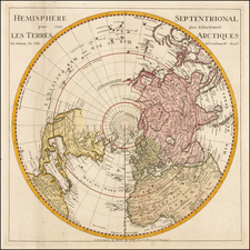
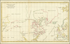
![[ Cook's Discoveries in Russian America ] Chart of the NW Coast of America and the NE Coast of Asia explored in the Years 1778 & 1779 . . . By James Cook](https://storage.googleapis.com/raremaps/img/small/68831.jpg)


|
||

|

|
|

|
The Streeter-Nebenzahl copy of Captain James Cook's map of the Northern Pacific and contiguous coasts of America and Asia, published in London in 1784, in what appears to be full original color.
The map includes the annotations of both Thomas W. Streeter (TWS) and Kenneth Nebenzahl. Streeter's collection is generally considered the finest Americana collection of the 20th Century and Nebenzahl is widely regarded as the most important American mapseller of the 20th Century.
As noted in Nebenzahl's hand at the lower right:
For the first time on a printed map the coastline of Alaska and the NW Coast is accurately portrayed. This was the official map to illustrate Capt. Cook's final voyage & displays his great contribution to the mapping of the area. Capt. Cook's route in the northern Pacific is shown in detail.
As noted in the map's legend below the title, the map is in part drawn from a Russian manuscript map.
Cook's chart is of tremendous importance, providing a highly important advance in the mapping of the coastlines depicted on the map. It is also a map of great controvery, having been the subject of an internal struggle among the editors of Cook's official account of his third voyage and those who actually accompanied Cook on his final voyage and were present at the time the obsevations were taken.
In summary, this chart was one of two competing charts, the other having been constructed by Henry Roberts, which was surpressed by the editors in favor of the chart offered here.
Both charts illustrated in great deal the known and unknown regions along the Northern Pacific Coastlines of America and Asia. The supressed chart had been prepared by Cook's primary cartographic assistant on his third voyage, Lieutenant Henry Roberts. Roberts served as the Masters Mate on the HMS Resolution. Because of disputes among the editors, Roberts' chart was not included in the final publication of the official account.
Cook's death left the production of the expedition's findings to two camps of editors. Henry Roberts and Captain King, the authors of the charts and journals and participants in the expedition found themselves at constant odds with Alexander Dalrymple, Cook's longtime rival, Sir Joseph Banks and Lord Keppel, among others. The production process was highly contentious. As noted by Hellen Wallis:
The maps and engravings were a major source of disagreement between the editors and the committee whose proceedings seem to have become more arbitrary with the succession of Keppel as First Lord. Banks and Webber supervised the engraving of the drawings while Alexander Dalrymple (none other) "at Lord Sandwich's desire," had direction of the charts and coastal views, with the exception of the general chart. Under the sole direction of the Admiralty this was being prepared by Lieutenant Henry Roberts, who had served as master's mate in the Resolution under William Bligh. . . . :
The [Dalrymple] & Sir Jos. are determined to have their Polar map & not mine, & to have none of the Hudson Bay Companies discoveries inserted saying that these things are only proper in the General Chart." . . .
This shows that the "Chart of the NW Coast of America and NE Coast of Asia" was the design of Dalrymple in collaboration with Banks, and explains the omission of any interior details of North America and of the name King George's Sound.
Roberts' "lost chart" contains a number of place names not found on the authorized version. The Roberts chart also includes important information, which had never previously appeared in print, showing the Coppermine River (information probably suppressed for commercial reasons by the Hudson's Bay Company) and the impossibility of a Northwest Passage through Hudson's Bay to the Pacific Ocean.
A complete discussion of the dispute among the editors is found here: /gallery/detail/35568
An important map in the cartographic history of the Northwest Coast of America and Polar Exploration, made all the more interesting by its unique printing history.
![[Caspian Sea / Kamtchatka] Geographica Nova ex Oriente gratiosissima, duabus tabulis specialissimis contenta, quaram una Mare Caspium. . .](https://storage.googleapis.com/raremaps/img/small/89998.jpg)