


|
||

|

|
|

|
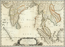
Fine example of this important early map of India & Southeast Asia by Nicolas Sanson the leading French mapmaker of the 17th Century.
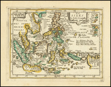
This first and present edition of the map was issued in 1654 as a separate map, and was then reissued to be included in Sanson's Atlas Les Cartes Générales de toutes parties du Monde (1658). Engraved by Jan van Somer, the map shows most of modern India, Bangladesh and Burma, the whole of Sri Lanka, Thailand, Malaysia, Laos, Cambodia, and Vietnam, and parts of Indonesia and China. It shows the cities and smaller settlements, rivers and mountain chains, as well as the borders of the seventeenth-century kingdoms and other major political divisions, most of them further subdivided.
At the time, much of India was ruled by the Mughal Emperor Shah Jahan (reigned 1628-58), although European powers held many forts along the coastal areas. Sri Lanka (Ceylon), Malaya and the Indonesian Archipelago were dominated by the Dutch East India Company (the VOC), while Burma, Thailand (Siam) and Veitnam largely remained under the control of native rulers.
Nicolas Sanson (1600-67) was the French preminent cartographer, being the official Geographer to Louis XVI, and his work was widely admired even long affter his time.
Nicholas Sanson (1600-1667) is considered the father of French cartography in its golden age from the mid-seventeenth century to the mid-eighteenth. Over the course of his career he produced over 300 maps; they are known for their clean style and extensive research. Sanson was largely responsible for beginning the shift of cartographic production and excellence from Amsterdam to Paris in the later-seventeenth century.
Sanson was born in Abbeville in Picardy. He made his first map at age twenty, a wall map of ancient Gaul. Upon moving to Paris, he gained the attention of Cardinal Richelieu, who made an introduction of Sanson to King Louis XIII. This led to Sanson's tutoring of the king and the granting of the title ingenieur-geographe du roi.
His success can be chalked up to his geographic and research skills, but also to his partnership with Pierre Mariette. Early in his career, Sanson worked primarily with the publisher Melchior Tavernier. Mariette purchased Tavernier’s business in 1644. Sanson worked with Mariette until 1657, when the latter died. Mariette’s son, also Pierre, helped to publish the Cartes générales de toutes les parties du monde (1658), Sanson' atlas and the first French world atlas.
![(First State!) [ India ] Tabula Asiae X](https://storage.googleapis.com/raremaps/img/small/94639.jpg)
![[Nepal] Latest Trekking Map North North of Jomsom Jomsom to Mustang](https://storage.googleapis.com/raremaps/img/small/44106.jpg)