


|
||

|

|
|

|
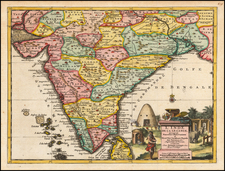
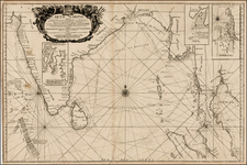
A highly attractive map embracing most of India, made during the height of the Mughal Imperial expansion.
This fine map, surrended by an elegant frame border, encompasses most of India. While the various traditional princely states of the subcontinent are distinguished by color, much of these states had by this time fallen under the rule of the Mughal Empire of Emperor Aurangzeb (reigned 1656-1707). During Aurangzeb's reign, the Mughals expanded their presence deep into southern India, although they never managed to conquer the entire area. Most notably the great Kingdom of Mysore was able to check their advance. At the same time, much of the coastal areas were under the auspices of various European powers, including the English, Dutch, Portuguese, French and Danes. Their numerous forts and trading posts are detailed on the map. An elegant cartouche with elephants and beehive-dwellings completes the composition.
Pieter van der Aa (1659-1733), based in the university town of Leiden, was one of the Netherlands' most prolific mapmakers and chroniclers of voyages of discovery.
Pieter van der Aa (1659-1733) was a Dutch mapmaker and publisher who printed pirated editions of foreign bestsellers and illustrated books, but is best known for his voluminous output of maps and atlases. Van der Aa was born to a German stonecutter from Holstein. Interestingly, all three van der Aa sons came to be involved in the printing business. Hildebrand was a copper engraver and Boudewyn was a printer.
![Colonel Mordaunt's Cock Match at Lucknow [Key Image]](https://storage.googleapis.com/raremaps/img/small/86563.jpg)