This item has been sold, but you can enter your email address to be notified if another example becomes available.


|
||

|

|
|

|
Stock# 37339
Description
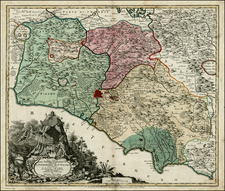
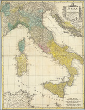
An attractive early 18th Century map of Italy, showing the various states that made up the peninsula.
This colorful map shows all of Italy, which at the time was divided in several different independent states and dependencies of foregin powers. The Papal States, which made up much of central Italy, were ruled directly by the Pope in Rome. The Duchy of Tuscany was still controlled by the Medici family. The Venetian Republic occupies the northeast corner of Italy, while Piedmont and Savoy are located in the northwest. The Kingdom of Naples and Sicily were long controlled by Spain, while Sardinia and Corsica were part of the Republic of Genoa.
The arms of 14 Italian states and regions adorn the sides of the map.
![[ Modern Italy ] Italia XIIII Nova Tabula (First state!)](https://storage.googleapis.com/raremaps/img/small/96564.jpg)