|
||

|

|
|

|
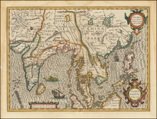
Decorative and historically important map of Southeast Asia, by Nolin and Coronelli, issued immediately prior to the Siamese Revolution of 1688, which henceforth restricted European activities in the kingdom.
The present work is an important map of Southeast Asia, extending from the southern part of the Indochinese Peninsula through Malaya, to the northern coastline of Java and the eastern part of Borneo. The map is filled with information including extensive soundings along coastlines and historical notations. The adornment of the map with a large elephant, making up the title cartouche, makes this map a favorite among collectors.
The cartographic detail on the map is groundbreaking, especially with respect to southern Siam. Its depiction of the region was by far the most accurate made to date, and would remain so for over a century thereafter. It is the result of France's first embassy to Southeast Asia in 1685, which was led by the Chevalier de Chaumont in the company of six Jesuit fathers. The route of their embassy is noted on the map.
At the time, Siam was experiencing the 'golden age' of the Ayutthaya Period (1351-1767). The capital city of Ayutthaya, located further up the Chao Praya River from modern Bangkok (noted on the map as 'Fortresse de Bankok'), is thought to have been the world's largest city at the time, with over 1 million residents. Ayutthaya is noted on the map as "Judtija", seemingly a phonetic interpretation of the true name.
Siam was first visited by Europeans in 1511, when Duarte Fernandes led a Portuguese embassy to Ayutthaya. While Siam was never formally colonized or claimed by a European power, as shown on the map, the French and Dutch had set up trading posts and Christian missions along the Chao Praya estuary. Brisk business was also done by European commercial agents in Ayutthaya itself.
However, shortly after Chaumont's embassy, there was intense popular uprising against the growing foreign presence in Siam. King Narai of Siam even went as far as to make a Greek adventurer, Constantine Phaulkon, his de facto prime minister. This was all too much for Siamese officials and nationalists.
In what became know as the Siamese Revolution of 1688, forces loyal to the Mandarin Phetracha overthrew Narai's government. Phetracha ascended to the throne and immediately expelled the French from Siam, while severely limiting the activities of the Dutch and other foreigners. This ensured that following the publication of the present map very little new European mapping was executed in Siam during the 18th-century.
The present map was a product of the collaboration between Jean-Baptiste Nolin (1657-1708), who was one of the official mapmakers to the King Louis XIV, and Vincenzo Maria Coronelli (1650-1715), a Venetian master who had been invited to Paris by the King to undertake cartographic projects, including the construction of the colossal 'Marly Globes'. The result of this collaboration was the most up to date and detailed contemporary maps of many parts of the World, at a time when France assumed a leading role in the exploration of America and Asia.
The Nolin-Coronelli mapping of Southeast Asia would become the standard for many decades after the creation of this map, and is a cornerstone of any collection of maps of Thailand and the Malay Peninsula.
Jean-Baptiste Nolin (ca. 1657-1708) was a French engraver who worked at the turn of the eighteenth century. Initially trained by Francois de Poilly, his artistic skills caught the eye of Vincenzo Coronelli when the latter was working in France. Coronelli encouraged the young Nolin to engrave his own maps, which he began to do.
Whereas Nolin was a skilled engraver, he was not an original geographer. He also had a flair for business, adopting monikers like the Geographer to the Duke of Orelans and Engerver to King XIV. He, like many of his contemporaries, borrowed liberally from existing maps. In Nolin’s case, he depended especially on the works of Coronelli and Jean-Nicholas de Tralage, the Sieur de Tillemon. This practice eventually caught Nolin in one of the largest geography scandals of the eighteenth century.
In 1700, Nolin published a large world map which was seen by Claude Delisle, father of the premier mapmaker of his age, Guillaume Delisle. Claude recognized Nolin’s map as being based in part on his son’s work. Guillaume had been working on a manuscript globe for Louis Boucherat, the chancellor of France, with exclusive information about the shape of California and the mouth of the Mississippi River. This information was printed on Nolin’s map. The court ruled in the Delisles’ favor after six years. Nolin had to stop producing that map, but he continued to make others.
Calling Nolin a plagiarist is unfair, as he was engaged in a practice that practically every geographer adopted at the time. Sources were few and copyright laws weak or nonexistent. Nolin’s maps are engraved with considerable skill and are aesthetically engaging.
Nolin’s son, also Jean-Baptiste (1686-1762), continued his father’s business.
![[Straits of Malacca, Sumatra, Java and Western Borneo]](https://storage.googleapis.com/raremaps/img/small/51765.jpg)
![[ Pacific Ocean and America -- The West Indies ] Descripcion De Las Yndias Ocidentales](https://storage.googleapis.com/raremaps/img/small/95683.jpg)
![Goldene Pagode [Shwedagon Pagoda, Yangon]](https://storage.googleapis.com/raremaps/img/small/90252.jpg)