


|
||

|

|
|

|
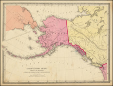
Important early map of Alaska and the Yukon Territory, highlighting the routes to the Gold Mining Regions in Alaska and the Klondike, published by Rand McNally in 1897.
The map shows many of the earliest routes to the Klondike, including the routes from Calgary and Edmonton. However, the map is relatively early, as noted by Streeter: "No route from Skagway over the White Pass is noted yet, and on the Chilkoot Pass route there is a prominent legend, "Healy's Store." Also, the Yukon is still shown as a "District" of Canada's Northwest Territories and not a territory in its own right (The district officially became the "Yukon Territory" on June 13, 1898).
The Chilkoot Pass (and from 1898 the nearby White Pass) soon became the main entry point into the Yukon. As shown on the map prospectors would sail from San Francisco, Seattle, Vancouver or Victoria up to the American ports of Skagway and Dyea, whereupon they would make the grueling ascent over the mountains into Canadian territory. This bi-national route was by far the fastest way to the Klondike, but was initially caught up in political uncertainty.
Relations between the United States and Canada in the region were initially tense. The Alaska-Canada Boundary was disputed between the nations. The U.S. threatened to block off the ports of Skagway and Dyea to Canadian and British vessels if those nations did not respect American sovereignty over the area. In turn, the Canadians were weary of having their territory inundated by thousands of American prospectors (and their firearms). During this time, 'All-Canadian routes' were opened up to the Yukon, being the river passages from Edmonton and Calgary shown on this map. However, the extremely long travel time and arduous portages of these routes rendered them impractical.
Fortunately, cooler heads prevailed, and American and Canadians officials reached something of a 'gentlemen's agreement', whereby the Canadians could use Dyea as a duty free port in exchange for not openly questioning U.S. control of the area, while the American authorities agreed to monitor and police some of the more unsavory elements of the American prospector community before they entered Canadian territory.
Another route to the goldfields is also shown on the map. In the summer months, the Yukon River was navigable by paddle wheeler from its mouth all the way up to Whitehorse, Yukon (up river from the Klondike). While lengthy, this route was the least arduous, as a prospector could travel the entire route form San Francisco to Dawson City by boat, in relative comfort. This was also the preferred way of accessing the American gold finds on the lower Yukon River.
The Klondike Gold Rush (1896-99) was one of the most sensational events of the fin de siècle period. Gold was fist discovered in the Klondike in what was then Canada's Northwest Territory on August 16, 1896. News quickly spread across North America from what was about the most remote corner of the continent. Newspapers exaggerated the potential of the bonanza in an effort to sell copies, and a mass sensation was born (note that the present map was sponsored by the Chicago Tribune!).
Over 100,000 people headed towards the Yukon, however, the region proved so dificult to reach that only 30,000 prospectors and 'entrepreneurs' actually arrived in the area near Dawson City. Only 4,000 prospectors managed to discover gold and the Yukon proved to be nothing like the El Dorado promised by the newspapers.
Gold had also been discovered at Nome in far western Alaska and in the lower reaches of the Yukon. However, it was not until 1899, when the bubble burst in the Klondike, that this region received great attention. As shown on the map, even as early as 1897, prospectors were sailing to St. Michael, Alaska, where local guides from the Yip'ik nation would help them cope with the extremely rugged topography and harsh climate. Proper guidance was absolutely necessary, as illustrated by an incident in October 1897, when 1,800 would-be miners en route to the Klondike were stranded on the Yukon River as it suddenly froze up for the season. Most had to return to St. Michael, abandoning their valuable equipment, while only 43 of these men managed to arrive in Dawson City that season.
This map is rare. We show no copies at auction since the Streeter sale in 1969. This example bearing the name "Chicago Tribune," is exceedingly rare. OCLC locates only 2 known examples.
Rand McNally & Co. is a large American map and navigation company best known for its annual atlases. The company got its start in 1856, when William Rand opened a print shop in Chicago. He was joined in 1858 by a new employee, Andrew McNally. Together, the men established their namesake company in 1868. Originally, the company was intended to print the tickets and timetables for the trains running to and through Chicago; their first railway guide was published in 1869.
By 1870, they had shifted from just printing to publishing directories, travel guides, and newspapers. Their first map appeared in 1872 in a railway guide. The map was produced using a new wax engraving method, a cheaper process that gave the company an edge.
By 1880 Rand McNally had entered the education market with globes, wall maps, and geography texts for students. In 1923, Rand McNally published the first Goode’s World Atlas, named after its editor, Dr. J. Paul Goode. For generations afterward, this would be the standard classroom atlas.
In 1899, William Rand left the company, but McNally and his family remained, controlling the company for over a century. In 1904, they published their first road map intended for automobiles and by 1907 were publishing Photo-Auto Guides, which combined photography and mapping to help drivers. In 1924, they produced the Auto Chum, a precursor to their famous road atlases. Rand McNally would remain the leader in road maps and atlases throughout the twentieth century.
In 1937, Rand McNally opened its first store in New York City. Ever on the frontier of technology, Rand McNally pioneered the scribing process for printing tickets in 1958 and printed their first full-color road atlas in 1960. Arthur Robinson developed his now-famous projection of Rand McNally in 1969. By the 1980s, the company was exploring digital reproduction and digital databases of maps for truckers. In the 1990s, they lead the charge to develop trip-planning software and websites. Today, most of its products are available online or in a digital format, including maps for tablets and phones.
![[Alaska to San Diego and San Qunitin, British Columbia] A Chart Shewing Part of the Coast of N.W. America, with the Tracks of His Majesty's Sloop Discovery and Armed Tender Chatham . . . (First Modern Map of the West Coast of North America)](https://storage.googleapis.com/raremaps/img/small/102067.jpg)

![[ Highlighting Routes To The Gold Regions ] Map of Alaska Compiled from the official Records of the General Land Office, U.S. Coast and Geodetic Survey and other sources . . . 1898](https://storage.googleapis.com/raremaps/img/small/98404.jpg)
![The Coast of Newfoundland From Plancentia to Cape Bonavista [and] A Draught of the River Plata in South America [and] Havana, Harbour [and] the Bay of Honda](https://storage.googleapis.com/raremaps/img/small/38599.jpg)