


|
||

|

|
|

|
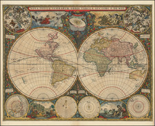
Striking example of Frederick De Wit's first map of the World, which was engraved for Hendrik Doncker's De Zee-Atlas ofte Water-Wereld.
For his first World map, De Wit draws on the cartographic features of Johannes Blaeu's Wall map of 1648. This is one of the very few maps to which De Wit adds a date. California is shown as an island, with no information given in the northwest part of America and no signs of the Great Lakes. South America is oversized and wide.
Only a single coastline is shown for New Zealand, while the discoveries of Tasman and others are reflected in the depiction of Australia. Korea is correctly shown as a peninsula, although Borneo and the Philippines are curiously configured.
The space between the hemispheres is richly adorned with celestial spheres, north and south polar projections, and astronomical diagrams. Representations of the four elements (air, water, fire and land) are shown, with the remaining areas embellished with garlands of fruits and flowers.
The map is dated in the lower neatlines, to the right of the centerfold.
This is the rarest of De Wit's maps and possibly the most decorative.
De Wit (1629 ca.-1706) was a mapmaker and mapseller who was born in Gouda but who worked and died in Amsterdam. He moved to the city in 1648, where he opened a printing operation under the name of The Three Crabs; later, he changed the name of his shop to The White Chart. From the 1660s onward, he published atlases with a variety of maps; he is best known for these atlases and his Dutch town maps. After Frederik’s death in 1706, his wife Maria ran the shop for four years before selling it. Their son, Franciscus, was a stockfish merchant and had no interest in the map shop. At the auction to liquidate the de Wit stock, most of the plates went to Pieter Mortier, whose firm eventually became Covens & Mortier, one of the biggest cartography houses of the eighteenth century.
![[Volcanos and the Subterranean World] Tabula Geographico-Hydrographica Motus Oceani, Currentes, Abyssos, Montes Igniuomos In Universo Orbe Indicans, Notat Haec Fig. Abyssos Montes Vulcanios](https://storage.googleapis.com/raremaps/img/small/95720.jpg)
![[ Wright- Molyneux Map ] [ New mapp of the world according to Mr. Edward Wright commonly called Mercator's projection ]](https://storage.googleapis.com/raremaps/img/small/99967.jpg)
![Hemisphere Septentrional du Globe Terrestre Veu en concave l'oeil estant au Pole AntArctique . . . 1696 [and] Hemisphere Superieur du Globe Terreste pour l'Horizon de Paris Veu en convexe l'oeil etant pose au zenith et a distance infinie du plan de projection . . . 1697](https://storage.googleapis.com/raremaps/img/small/85541.jpg)