The item illustrated and described below is sold, but we
have another example in stock. To view the example which
is currently being offered for sale, click the
"View Details" button below.
1777 Maurille Antoine Moithey
$ 1,700.00


|
||

|

|
|

|
Stock# 37177
Description
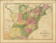
Nice example of the 1780 edition of this scarce separately issued broadside Revolutionary War Map of the British Colonies.
The map includes a remarkable amount of historical, topographical and military notes and details concerning the British Colonies and neighboring regions, along with a large inset map of the Pacific, showing the various French trading routes to the new world from Brest, Nantes, Rochefort, Lisbon and Cadiz.
Excellent Indian & Colonial detail, especially in the Ohio Valley and western Virginia, where a number of early English forts and settlements are noted. There are also some dates regarding conflicts going back to the French & Indian War in the Ohio Valley.
Reference
Sellers and Van Ee 155.


![[Battle of Lexington] Journee de Lexington . . .](https://storage.googleapis.com/raremaps/img/small/94722.jpg)