


|
||

|

|
|

|
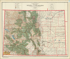
Scarce large format map of Colorado, published by the General Land Office, with inset maps of Denver, Cripple Creek and Leadville.
The map shows county and land district boundaries, Indian reservations, forest reserves, and private land claims in color.
Also shown are public land surveys, towns and cities, railroads, military reservations, and locations of U.S. land offices. Relief shown in color.
A fine early map of Colorado.
The General Land Office (GLO) refers to the independent agency in the United States that was in charge of public domain lands. Created in 1812, it assumed the responsibilities for public domain lands from the United States Department of the Treasury. The Treasury had overseen the survey of the Northwest Territory, but as more area was added to the United States, a new agency was necessary to survey the new lands.
Eventually, the GLO would be responsible for the surveying, platting, and sale of the majority of the land west of the Mississippi, with the exception of Texas. When the Secretary of the Interior was created in 1849, the GLO was placed under its authority. Until the creation of the Forest Service in 1905, the GLO also managed forest lands that had been removed from public domain. In additional to managing the fees and sales of land, the GLO produced maps and plans of the areas and plots they surveyed. In 1946, the GLO merged with the United States Grazing Service to become the Bureau of Land Management.