


|
||

|

|
|

|
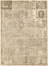
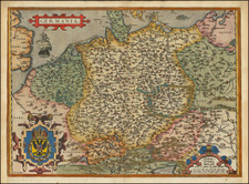
Fine example of G.P. Finckh's version of Philip Apian's 1568 map, the first printed map of Bavaria, Engraved by Ainling.
Apian's map of Bavaria is considered to be a pioneering monument of modern cartography. In 1554, Duke Albrecht of Bavaria ordered Philip Apian (son of the famous mathematician and cosmographer Peter Apian) to create a map of Bavaria for the Bairische Chronik of Johannes Aventinus written 1526 to 1533. For the next 7 years, Apian travelled through Oberbayern and Niederbayern, Oberpfalz, Archbishopric Salzburg and Bishopric Eichstätt, conducting survey of the landscape based on methods of trigonometry and triangulation, creating the first map of an entire country by this method. He then spent the next two years creating his masterwork, a 5 x 5 meter sized map in scale 1:45.000, which was later colored by Bartel Refinger.
Philip Apian (1531-1589) was successor to his father Peter as the professor of mathematics at Ingolstadt University and the first cartographer to produce a complete map of Bavaria.
The map remained in the same Library, until it was destroyed by a fire in 1782.
A smaller Bairische Landtafeln, based on the 1563 Apian map, was prepared in 1568. The map was so precise that Bavaria did not conduct any other large scale land survey until the early 19th century. Later maps of Bavaria were usually merely updated versions of Apian's map with more elaborate writing or decorative frames. The map is so detailed that even the spot where his brother died, after falling from his horse, is recorded. It is marked by a cross near the town of Ainhaus.
The map features a large vignette with a portrait of Maximilian I "The Great", the Elector of Bavaria (reigned, 1597-1651), widely considred to be the country's finest ruler. The arms of Bavaira, which are flanked by lions, occupy the upper-right corner of the map, above a view of Munich, while a view near the bottom of the map shows putti with an assortment of surveying equipment. An attractive holdover from Renaissance era cartography are the windheads which surround the map.
![[ Lower Rhine River & Wesser River Region ] Die dritte Tafel des Rheinstroms / Innhaltend das Nider Teutschlandt](https://storage.googleapis.com/raremaps/img/small/81288.jpg)