|
||

|

|
|

|
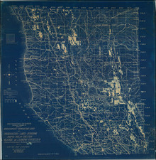
Rare promotional pocket map, promoting the Sant Fe Railroad's arrival in Southern California.
The vero of the pocket map shows the name of Chas. T. Parsons at 239 North Main Street, and early Santa Fe ticket agent.
The map shows the Santa Fe Railroad's operations in Southern California, extending from National City and San Diego in the south to Barstow in the north.
A number of early railway stations are shown, including Stewart's, Cordero and Soledad in San Diego County. A second San Diego County line extends through El Cajon, Poway and "Bernardo," before curving back to Oceanside. A northern San Diego County line runs from Oceanside to Ysadora, De Luz, Fallbrook, Ranchito, Temecula, Wildomar and Elsinore.
In Los Angeles County, Ballona Harbor is noted to the south of Santa Monica, an early name for Playa Del Rey, and the location of the first attempt at a dredged harbor in Santa Monica Bay. Under contract with the Atchison, Topeka & Santa Fe Railroad, the Moye Wicks' syndicate spent $300,000 to dredge "Ballona Harbor" in the late 1880s, for shipping to the Orient, a plan that latest for about 3 years.
An extremely rare pocket map. We note no other examples at auction or in dealer catalogs and no examples in OCLC or otherwise.
Rand McNally & Co. is a large American map and navigation company best known for its annual atlases. The company got its start in 1856, when William Rand opened a print shop in Chicago. He was joined in 1858 by a new employee, Andrew McNally. Together, the men established their namesake company in 1868. Originally, the company was intended to print the tickets and timetables for the trains running to and through Chicago; their first railway guide was published in 1869.
By 1870, they had shifted from just printing to publishing directories, travel guides, and newspapers. Their first map appeared in 1872 in a railway guide. The map was produced using a new wax engraving method, a cheaper process that gave the company an edge.
By 1880 Rand McNally had entered the education market with globes, wall maps, and geography texts for students. In 1923, Rand McNally published the first Goode’s World Atlas, named after its editor, Dr. J. Paul Goode. For generations afterward, this would be the standard classroom atlas.
In 1899, William Rand left the company, but McNally and his family remained, controlling the company for over a century. In 1904, they published their first road map intended for automobiles and by 1907 were publishing Photo-Auto Guides, which combined photography and mapping to help drivers. In 1924, they produced the Auto Chum, a precursor to their famous road atlases. Rand McNally would remain the leader in road maps and atlases throughout the twentieth century.
In 1937, Rand McNally opened its first store in New York City. Ever on the frontier of technology, Rand McNally pioneered the scribing process for printing tickets in 1958 and printed their first full-color road atlas in 1960. Arthur Robinson developed his now-famous projection of Rand McNally in 1969. By the 1980s, the company was exploring digital reproduction and digital databases of maps for truckers. In the 1990s, they lead the charge to develop trip-planning software and websites. Today, most of its products are available online or in a digital format, including maps for tablets and phones.
![[Eastern San Diego County] Cuyamaca Quadrangle](https://storage.googleapis.com/raremaps/img/small/83422.jpg)