The item illustrated and described below is sold, but we
have another example in stock. To view the example which
is currently being offered for sale, click the
"View Details" button below.


|
||

|

|
|

|
Stock# 36910
Description
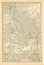
One of the earliest separately issued maps of Idaho to appear in a Commecial Atlas.
The map is slighly detailed, showing towns, mines, roads, railroads, mountains, rivers, Indian reservations, military reserves, post offices, forts, lakes, etc.
From an early edition of Rand McNally & Company's Business Atlas.
![[Montana, Wyoming, Dakota, Upper Missouri River] Amer. Sep. No. 40. Partie des Etats Unis](https://storage.googleapis.com/raremaps/img/small/93546.jpg)
![Nouvelle Carte Du Mexique, Du Texas Et D'Une Partie Des Etats Limitrophes . . . 1840 [Proposed Railroads In Texas -- First Appearance of Arizona on a Printed Map]](https://storage.googleapis.com/raremaps/img/small/103480.jpg)