This item has been sold, but you can enter your email address to be notified if another example becomes available.


|
||

|

|
|

|
Stock# 36816
Description
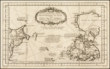
Detailed map of the West Coast of North America, extending from Mount St. Elias, Alaska in the north to Monterey Bay in the south, published in the Atlas du Voyage de la Perouse.
The map exhibits excellent detail along the coast, tracking La Perouse's voyage on a nearly daily basis. The map also highlights the incomplete nature of La Perouse's survey of the coastline, with many areas left blank, with the expectation of follow up voyages. Topographical details are included where observed by La Perouse.
La Perouse set sail from France in 1785 to continue the discoveries of Captain Cook. He was shipwrecked in 1788 and died during the voyage, but his narrative, maps, and views survived and were published in 1797.
Condition Description
Two minor rust spots.