|
||

|

|
|

|
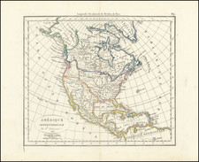
Fine example of the rare first edition of Antonio de Herrera y Tordesillas' map of America, the Pacific Ocean and the Eastern part of Asia, from his Descripcion de las Indias Occidentalis, published as part of his Historia General, in Madrid in 1601.
This rare 1601 map is the earliest printed Spanish map to depict with any real size and accuracy the complete continents of North and South America. It is also the earliest Spanish map to depict Korea, Japan, the Philippines, and the Pacific Ocean, a region which the Spanish regarded as their Mare Closum (Closed Sea). The Spanish policy of secrecy precluded the dissemination of geographical knowledge, a policy strictly and apparently affectively enforced, as prior to Herrera's work, no Spanish printer made any attempt to provide meaningful detail to these regions. The map was followed shortly thereafter by Hernando de Solis' World map and map of America published in 1603 (although the America map was apparentl begun as early as 1598).
Herrera y Tordesilla's general map is drawn from the manuscript map of Juan Lopez de Velasco (ca 1575), of which there are 4 known surviving examples, including one at the John Carter Brown Library, which this printed version most closely follows. The map illustrates the Line of Demarcation between the Spanish and Portugese colonial claims (running through Brazil in America and through China and the Malay Peninsula in Asia), although the East Indies are shifted some 40 degrees to the East, placing them (not surprisingly) under Spanish control. California is named, as are the Isle of Cedro and C. de Fortun, with Florida named in the East. Burden notes that the general map provides greater detail in Florida, curiously so.
The first edition of Herrera's work is of the utmost rarity and the plates were never again used. The maps were copied in Amsterdam in 1622 and after, but it would not be until 1726 before another Spanish edition of Herrera's work would include maps (a newly engraved set).
We are aware of only a single example of the map offered at auction in the past 30 years.
![Opusculum Geographicum Rarum [with map:] Universalis Orbis Descriptio, Cogimur e Tabula Pictos Ediscere Mundos.](https://storage.googleapis.com/raremaps/img/small/95970.jpg)