|
||

|

|
|

|
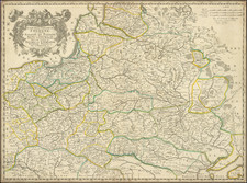
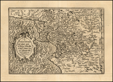
An attractive pictorial map of what is now Northern Poland, but was then part of German Prussia, made shortly before World War II.
This colorful map depicts what is now north-central and northeastern Poland, as well as the Kalliningrad enclave of Russia. The map was made in Germany in 1937, to illustrate the region that was still part of the German Reich. While the region had always had a significant Polish population, most of the area formed a tradtional part of the Kingdom of Prussia, which became the dominant German state during German Unification in 1871. Following World War I the region was physically severed from Germany, owing to the creation of a coastal corridor which connected Poland to the Baltic Sea. Danzig (now Gdansk), became a free city under international administration.
All of the major towns are pictorially represeted on the map, notably with images of signature buildings, while the coast of arms of the towns line the work. Many places figured prominently in history. Thorn was the hometown of the great Polish astronomer Nicholas Copernicus, and Konigsberg (now Kalliningrad) was the home of the pholosopher Immanuel Kant.
Following World War II, most of the region became a part of Poland, while the northeastern areas became a part of the USSR.
![(First World War - Battle of the Vistula River) восточного отряда по Ивангородскому Маневру [Eastern Detachment Along the Ivangorod Maneuver]](https://storage.googleapis.com/raremaps/img/small/78086.jpg)