|
||

|

|
|

|
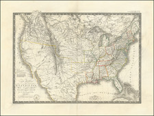
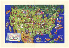
The only known example of a separately issued example of the Southern Sheet for Abraham Bradley's postal map of the United States, one of the most important maps early maps of the United States and a landmark in the both the history of cartography and American Postal history.
The present example of the map is the first edition, first state of the map and the only known unbound single sheet example of this southern sheet. This newly discovered map raises new questions about the printing and publication history of Bradleys' Postal Map. Most notably, it strongly suggests that the sheet was intended as a separate issue, making it the earliest separately issued map of the Southern States published in America.
Bradley's map is normally found as a 4-sheet map, although there is also a single known example of the Northeastern Sheet which is believed to have been separately issued. This sheet and the northeastern sheet were joined in a way that required an more or less horizontal cut near the Del-Mar-Va peninsula and an irregular cut along the east-west joining point.
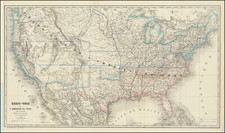
First issued in 1796, Bradley's postal map is among the most importan maps in American history. Published in the 18th Century, it is one of only 4 large format maps of the United States to have been published in America prior to 1800, two of which (maps by Abel Buell and John Norman) are unlikely to ever again appear on the market.
The map provides and exceptionally detailed look at the post offices and postal routes of the Southern States, as they existed at the end of the 18th Century, locating every post office then in operation.
In 1796, Bradley published his first Map of the United States, Exhibiting the Post-Roads, the Situations, Connections, and Distances of the Post-Offices. At that time, less than 15 years after the end of the War of Independence, most citizens of the fledgling United States still had no real conception of the magnitude of their young nation. Bradley's postal map, with its schedule chart, was a perfect combination of Bradley's skills and obsession for precision scheduling. This unique U.S. map was on public display in almost every large post office in the country and provided citizens with an impressive visual depiction of the scope of the United States at a time when the search for a national culture and national identity was at its height, after the final and official separation from Great Britain. The inclusion of stagecoach schedules promoted, encouraged and broadened popular notions of the concept of time beyond seasonal and religious practices.
For many colonial residents, the Bradley's map was the iconic symbol of a unified United States. Citizens began to consider (and later demand adherence to) weekly and daily notations of time, as measured by the institution of regularly-scheduled mail service.
A fascinating historical footnote for Bradley's map was its use by Louis Philippe, Duc d'Orléans, future King of France (1830-1848), during his travels in America. Louis Philippe spent more than three years in American exile, from 1796 to 1800. At the beginning of his exile in 1796, he and his two brothers visited an aging George Washington at Mount Vernon, where they revealed their desire to explore the mysterious interior of America. Washington presented them with a copy of Bradley's map and outlined a route for the brothers in red. The map became a favorite keepsake for Louis Philippe, who years later, as King of France, would proudly produce the map for visitors and share the story of how Washington had redlined the map in his own hand for a young Louis Philippe and his brothers.
The present map is the first state of the 1796 edition.
18th Century editions of the map (of which there were 4) are of the utmost rarity. The last auction record for an 18th Century edition of the map was in 1976. The Caldwell & Buehler articles notes only one known example of the first edition, first state (Library of Congress) and 4 complete examples of the first edition, second state (American Geographical Society, American Philosophical Society, Library of Congress and New York Public Library.
The present example is the only known example of the Southern Sheet to appear as a separate issue.
Abraham Bradley was born in Litchfield, Connecticut. He is an important figure not only in early American cartography, but in early American history as well. Initially, Bradley trained as a lawyer and moved to the Wyoming Valley of Pennsylvania to practice. There he met Judge Thomas Pickering, who took Bradley with him to Philadelphia when he was appointed Postmaster General by George Washington in 1791.
As Pickering's clerk, Bradley created postal maps which showed the budding system of post offices and routes. A self-taught mapmaker, Bradley quickly gained considerable skill and became well-known for this carefully drawn maps. His most famous map is the postal route map of 1796, which shows the young United States and includes an innovative table that calculated the time it would take a letter to travel around the country.
In 1799, Bradley was appointed Assistant Postmaster General, a position he would hold until 1829. As part of his duties, Bradley supervised the moving of the General Post Office Department from Philadelphia to Washington DC. In 1804, with the help of British mapmaker Aaron Arrowsmith, Bradley updated his postal map, which featured in practically every post office in the states and territories. Bradley would continue to create route maps, and to update his most famous map, throughout his career, including in 1810 and 1825.
During the burning of Washington DC in the War of 1812, Bradley housed the records and archives of the General Post Office Department in his Maryland farmhouse. His service with the Post Office came to an abrupt end, however, with the election of Andrew Jackson. Although he had served under five Postmasters General, Jackson dismissed Bradley for partisan reasons. Bradley then served as secretary to the Franklin Insurance Company. He died at his farmhouse in 1838, leaving behind eight children. He is remembered for his careful custodianship of the nascent Post Office, and for creating maps that made Americans feel connected to their fellow citizens.
![[ American Revolution - Satirical Warning To Dutch Commerce ] Den Door List en Geweld Aangevallen Leeuw.](https://storage.googleapis.com/raremaps/img/small/99580.jpg)