


|
||

|

|
|

|
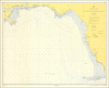
A scarce and important large-format sea chart featuring Southern Florida, Cuba and the Bahamas, produced by the firm of E. & G.W. Blunt, the authoritative American publishers of maritime cartography during the 19th-century.
This fine chart embraces Southern Florida from the Tampa Bay area southwards, the entire island of Cuba, the Bahamian Archipelago, the Turks & Caicos, and the Windward Passage, which divides Cuba from Haiti (Hispaniola). It has the perspective of having the westward direction orientated towards the top. The coastal areas and offshore banks feature copious bathymetric soundings and remarks for navigation, while the coastal conventions display topographic relief and distinguish features such as tidal marshlands.
Blunt's chart was, during its time, the most important navigational guide to these waters available to American mariners, having been predicated on a variety of advanced American, British and Spanish surveys. Issued during the Third Seminole War (1855-8), this chart, that allowed vessels to negotiate the treacherous waters off Southern Florida, would have been highly valued.
The mapping of the coasts of Florida is still largely based on the epic surveys conducted for the British government from 1765 to 1772, namely, William Gerard De Brahm's mapping of the Atlantic (eastern) coast of the peninsula, George Gauld's mapping of the Florida Keys and Tampa Bay and Bernard Romans' charting of the area around Charlotte Harbor. As noted on the map, under the heading, 'Authorities for the Coast of Florida', the mapping of the Gulf Coast, and the Everglades in particular, has been improved upon by the 1838 surveys conducted by Commander L. M. Powell, working as part of the U.S. Coast Survey program (which aimed to systematically map all of America's coasts). Moreover, it noted that much of the topographical detail was supplied from the surveys of the U.S. Amy's Topographical Bureau, conducted by Colonel J. J. Albert during the 1830s. The flag marked with an "A" which adorns the interior of Florida represents a signal flag employed by the U.S. Coastal Survey. The map features the busting trading port of Key West (then the most important settlement in Florida) as well as the series of forts founded by the U.S. Army during the Seminole Wars, including Fort Jupiter (Jupiter Beach), Fort Pierce, Fort Lauderdale and Fort Brooke (near Tampa).
The mapping of the Bahamian Archipelago and the Bahamas Bank is based on recent surveys conducted for the British Admiralty, including the work of Lt. Anthony De Mayne in in 1827, Captain Richard Owen in 1832 and Captain Edward Barnett in 1838. The detail with respect to the sounding of the Bank is an especially impressive feat of hydrography.
The mapping of Cuba is based on Spanish surveys conducted by Don Ventura de Barcaizetegui in 1793 and José de Rio Cosa in 1804, with more recent embellishments from the Armada Real's surveying vessels the Ligiera, the Clarita and the Havanera. The upper sheet of the chart features an especially fine inset containing a 'Plan of Havana from the Spanish Surveys'.
The charting of the Windward Passage (between Cuba and Hispaniola) was especially important, as it was the busiest single access point for shipping between the Atlantic Ocean and the Caribbean Sea.
This chart is one of the finest productions of the firm of E. & G.W. Blunt, by far the most important commercial American publishers of maritime cartography during the 19th-century. The enterprise was founded in the 1790s by Edmund March Blunt, a bookseller in Newburyport, Massachusetts, who sold his merchandise at a bookshop called "The Sign of the Bible". In 1796, with the aid of the eminent navigator Captain Lawrence Furlong, Blunt published The American Coast Pilot, one of the seminal works on American navigation, with the 1804 edition being the first to contain maps. The work was wildly popular, and was reissued many times, eventually numbering 21 editions. In 1811, Blunt moved his business to New York and published under the "Sign of the Quadrant". Shortly thereafter, his son, Edmund Jr. assumed control of the firm, and accepted a commission to produce maps for the United States Coast Survey, making his charts the definitive sources for American maritime navigation. The Blunt firm prospered until the 1880s.
The present chart is evidence of the fascinating process by which the Blunt firm, and many of its competitors, produced sea charts. This chart is made up of three distinct sheets, of which the upper sheet, is discreetly entitled, 'U. States Southern Coast. Sheet VI. …1844', the middle sheet, 'U. States Southern Coast. Sheet VII. …1844', and the lower sheet entitled, 'Cuba and the Windward Passages …1856'. Chart-makers often produced a series of square inter-linkable panels, which could be combined with others in a bespoke manner. Each square was printed with borders of latitude and longitude markings, but where joined these borders were either trimmed or glued over, while the exposed margins of the combined chart would form an integrated border. In this particular case, it was decided to create a chart that would extend to include Southern Florida, much of Cuba, the Bahamas and the Windward Passage. In other instances, the Blunt firm used the same Southern Florida (upper) section, and combined it with panels detailing the U.S. coastline to the northwards. This way, the Blunt firm was able to create bespoke charts for its clients. The sheets that comprise this chart were first issued in 1827 as part of the Blunts' 10-sheet maritime atlas. The sheets were progressively updated and reissued until the 1860s.
The present chart is scarce, and is an important work relating the scientific mapping of Florida, representing American maritime cartography at its apogee.
![(Coast of Florida, Georgia and the Carolinas] [To The Members Of The Nautical Institution And Ship-Masters' Society Of The City Of New York, This Chart, Extending From Lat. 40°15 N., Long. 72°15 W., to Lat. 22°35 N., Long. 80°25 W., Is Respectfully Dedicated / By Their Obedient Servant Edmund M. Blunt]](https://storage.googleapis.com/raremaps/img/small/77294.jpg)
![West Indies. Corrected to 1846 [Bermuda Inset]](https://storage.googleapis.com/raremaps/img/small/94053.jpg)
![[ The King of Florida ] Der Konig in Florida](https://storage.googleapis.com/raremaps/img/small/94085.jpg)
![The North Coast of the Gulf of Mexico from St. Marks to Galveston . . . 1844 . . . Additions to 1856, including the Surveys of Comr. Powell, Lt. Simmes & Profr. Coffin, U.S. Navy [and] St. Marks to Galveston. Sheet II. . . . 1845. Additions to 1851 . . . .](https://storage.googleapis.com/raremaps/img/small/89497.jpg)
![[Pensacola] Plan de la Baye De Pansacola . . . 1744](https://storage.googleapis.com/raremaps/img/small/87767.jpg)